San Jacinto del Cauca geodata
San Jacinto del Cauca (Bolívar) is a seat of a second-order administrative division; located in Colombia in America/Bogota (GMT-5) time zone. In our database, there are 1053 cities with bigger population. Compared to other cities in Colombia, 82% of cities are located further ↓South; 52.7% of cities are located further ←West and 90.2% of cities have higher elevation than San Jacinto del Cauca. Note1


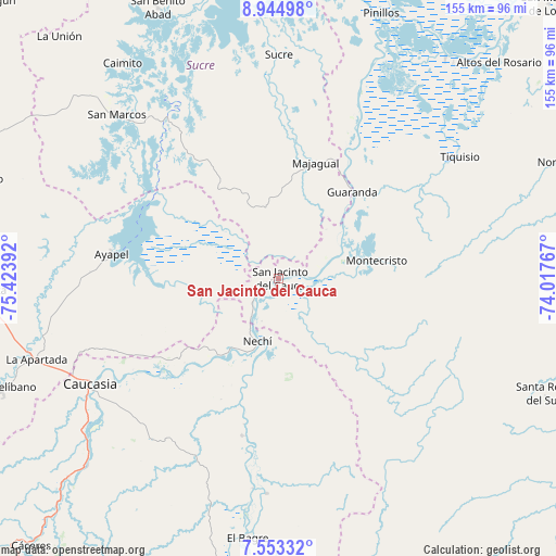
San Jacinto del Cauca GPS coordinates[2]
8° 14' 59.136" North, 74° 43' 14.844" West
| Map corner | latitude | longitude |
|---|---|---|
| Upper-left | 8.94498°, | -75.42392° |
| Center: | 8.24976°, | -74.72079° |
| Lower-right: | 7.55332°, | -74.01767° |
| Map W x H: | 154.7×154.7 km | = 96.1×96.1mi |
| max Lat: | 13.38166° ⇑18% North |
| San Jacinto del Cauca: | 8.24976° |
| min Lat: | ⇓82% South -4.21528° |
| min Long | San Jacinto del | max Long |
| -81.70636° | -74.72079° | -67.06996° |
| W 52.7%⇐ | ⇒47.3% E |
Elevation
Elevation of San Jacinto del Cauca is 29 m = 95 ft, and this is 1120.3 m = 3676 ft below average elevation for this country.
| Max E: |
3342 m = 10965 ft | 90.2% |
| Avg. | 1149.3 m = 3771 ft | |
| San Jacinto del Cauca | 29 m = 95 ft | |
Min E: |
1 m = 3 ft | 9.8% |
See also: Colombia elevation on elevation.city.
Geographical zone
San Jacinto del Cauca is located in North Torrid zone (between Equator and Tropic of Cancer). Distance of Equator is 917.3 km =570 mi to South.| Distance of | km | miles | from San Jacinto del Cauca |
|---|---|---|---|
| North Pole | 9089.8 | 5648.1 | to North |
| Arctic Circle | 6483.9 | 4028.9 | to North |
| Tropic Cancer | 1688.6 | 1049.2 | to North |
| Equator | 917.3 | 570 | to South |


Nearby cities:
15 places around San Jacinto del Cauca: (largest is in red/bold)
• Achí
39.8 km =24.7 mi,  26°
26°
• Ayapel
46.7 km =29 mi,  278°
278°
• Caimito
74.2 km =46.1 mi,  324°
324°
• Caucasia
59.7 km =37.1 mi,  240°
240°
• El Bagre
72.5 km =45 mi,  187°
187°
• Guaranda
31.6 km =19.6 mi,  39°
39°
• La Apartada
71.4 km =44.4 mi,  251°
251°
• Majagual
33.9 km =21.1 mi,  17°
17°
• Montecristo
27.7 km =17.2 mi,  79°
79°
• Nechí
18.3 km =11.4 mi,  199°
199°
• Pueblo Nuevo
26.1 km =16.2 mi,  267°
267°
• San Carlos
51.2 km =31.8 mi, 186°
• San Marcos
63.9 km =39.7 mi, 315°
• Sucre
62.4 km =38.8 mi,  359°
359°
• Tiquisio
60.8 km =37.8 mi,  55°
55°
Sources, notices
• [Note1] Compared only with cities in Colombia existing in our database
• [Src1] Map data: © OpenStreetMap contributors (CC-BY-SA)
• [Src2] Other city data from geonames.org with taken over terms of usage.
• [Src3] Geographical zone / Annual Mean Temperature by Robert A. Rohde @ Wikipedia
