Abriaquí geodata
Abriaquí (Antioquia) is a seat of a second-order administrative division; located in Colombia in America/Bogota (GMT-5) time zone. With population of 1,281 people, there are 905 cities with bigger population in this country. Compared to other cities in Colombia, 70.3% of cities are located further ↓South; 81.3% of cities are located further →East and 76.8% of cities have lower elevation than Abriaquí. Note1


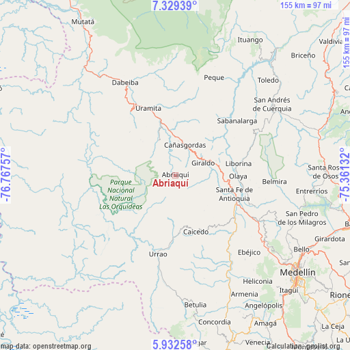
Abriaquí GPS coordinates[2]
6° 37' 53.328" North, 76° 3' 51.984" West
| Map corner | latitude | longitude |
|---|---|---|
| Upper-left | 7.32939°, | -76.76757° |
| Center: | 6.63148°, | -76.06444° |
| Lower-right: | 5.93258°, | -75.36132° |
| Map W x H: | 155.3×155.3 km | = 96.5×96.5mi |
| max Lat: | 13.38166° ⇑29.7% North |
| Abriaquí: | 6.63148° |
| min Lat: | ⇓70.3% South -4.21528° |
| min Long | Abriaquí | max Long |
| -81.70636° | -76.06444° | -67.06996° |
| W 18.7%⇐ | ⇒81.3% E |
Elevation
Elevation of Abriaquí is 1915 m = 6283 ft, and this is 765.7 m = 2512 ft above average elevation for this country.
| Max E: |
3342 m = 10965 ft | 23.2% |
| Abriaquí | 1915 m 6283 ft | |
| Avg. | 1149.3 m = 3771 ft | |
Min E: |
1 m = 3 ft | 76.8% |
See also: Colombia elevation on elevation.city.
Geographical zone
Abriaquí is located in North Torrid zone (between Equator and Tropic of Cancer). Distance of Equator is 737.4 km =458.2 mi to South.| Distance of | km | miles | from Abriaquí |
|---|---|---|---|
| North Pole | 9269.7 | 5759.9 | to North |
| Arctic Circle | 6663.8 | 4140.7 | to North |
| Tropic Cancer | 1868.6 | 1161.1 | to North |
| Equator | 737.4 | 458.2 | to South |


Nearby cities:
15 places around Abriaquí: (largest is in red/bold)
• Anzá
43.3 km =26.9 mi,  147°
147°
• Belmira
44.1 km =27.4 mi,  93°
93°
• Buriticá
19.9 km =12.4 mi,  60°
60°
• Caicedo
26.7 km =16.6 mi,  160°
160°
• Cañasgordas
13.9 km =8.6 mi,  18°
18°
• Frontino
17.3 km =10.7 mi,  333°
333°
• Giraldo
13.5 km =8.4 mi,  66°
66°
• Liborina
28.3 km =17.6 mi,  79°
79°
• Olaya
27.8 km =17.3 mi, 90°
• Sabanalarga
36.5 km =22.7 mi,  48°
48°
• San Jerónimo
42.6 km =26.5 mi,  119°
119°
• Santa Fe de Antioquia
27.4 km =17 mi,  107°
107°
• Sopetrán
38.3 km =23.8 mi, 112°
• Uramita
32.2 km =20 mi,  337°
337°
• Urrao
35.8 km =22.2 mi,  192°
192°
Sources, notices
• [Note1] Compared only with cities in Colombia existing in our database
• [Src1] Map data: © OpenStreetMap contributors (CC-BY-SA)
• [Src2] Other city data from geonames.org with taken over terms of usage.
• [Src3] Geographical zone / Annual Mean Temperature by Robert A. Rohde @ Wikipedia
