Palestina geodata
Palestina (Huila) is a seat of a second-order administrative division; located in Colombia in America/Bogota (GMT-5) time zone. With population of 2,027 people, there are 795 cities with bigger population in this country. Compared to other cities in Colombia, 91.8% of cities are located further ↑North; 82% of cities are located further →East and 63% of cities have lower elevation than Palestina. Note1


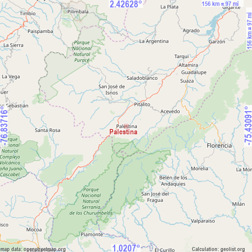
Palestina GPS coordinates[2]
1° 43' 25.032" North, 76° 8' 2.508" West
| Map corner | latitude | longitude |
|---|---|---|
| Upper-left | 2.42628°, | -76.83716° |
| Center: | 1.72362°, | -76.13403° |
| Lower-right: | 1.0207°, | -75.43091° |
| Map W x H: | 156.3×156.3 km | = 97.1×97.1mi |
| max Lat: | 13.38166° ⇑91.8% North |
| Palestina: | 1.72362° |
| min Lat: | ⇓8.2% South -4.21528° |
| min Long | Palestina | max Long |
| -81.70636° | -76.13403° | -67.06996° |
| W 18%⇐ | ⇒82% E |
Elevation
Elevation of Palestina is 1546 m = 5072 ft, and this is 396.7 m = 1302 ft above average elevation for this country.
| Max E: |
3342 m = 10965 ft | 37% |
| Palestina | 1546 m 5072 ft | |
| Avg. | 1149.3 m = 3771 ft | |
Min E: |
1 m = 3 ft | 63% |
See also: Colombia elevation on elevation.city.
Geographical zone
Palestina is located in North Torrid zone (between Equator and Tropic of Cancer). Distance of Equator is 191.6 km =119.1 mi to South.| Distance of | km | miles | from Palestina |
|---|---|---|---|
| North Pole | 9815.4 | 6099 | to North |
| Arctic Circle | 7209.5 | 4479.8 | to North |
| Tropic Cancer | 2414.3 | 1500.2 | to North |
| Equator | 191.6 | 119.1 | to South |


Nearby cities:
15 places around Palestina: (largest is in red/bold)
• Acevedo
28.5 km =17.7 mi,  71°
71°
• Albania
52.3 km =32.5 mi,  147°
147°
• Belén de los Andaquíes
44.3 km =27.5 mi,  139°
139°
• Elías
38.6 km =24 mi,  33°
33°
• Isnos
24.4 km =15.2 mi,  339°
339°
• Isnos
26.4 km =16.4 mi,  333°
333°
• Morelia
52.4 km =32.6 mi,  120°
120°
• Oporapa
36.7 km =22.8 mi,  24°
24°
• Pitalito
17.2 km =10.7 mi, 32°
• Saladoblanco
31.5 km =19.6 mi, 18°
• San Agustín
22.7 km =14.1 mi,  319°
319°
• San José del Fragua
47 km =29.2 mi,  157°
157°
• Santa Rosa
48.9 km =30.4 mi,  267°
267°
• Suaza
47 km =29.2 mi,  53°
53°
• Timaná
35.6 km =22.1 mi,  39°
39°
Sources, notices
• [Note1] Compared only with cities in Colombia existing in our database
• [Src1] Map data: © OpenStreetMap contributors (CC-BY-SA)
• [Src2] Other city data from geonames.org with taken over terms of usage.
• [Src3] Geographical zone / Annual Mean Temperature by Robert A. Rohde @ Wikipedia
