Samaná geodata
Samaná (Caldas) is a seat of a second-order administrative division; located in Colombia in America/Bogota (GMT-5) time zone. In our database, there are 1053 cities with bigger population. Compared to other cities in Colombia, 52% of cities are located further ↑North; 54% of cities are located further →East and 60.2% of cities have lower elevation than Samaná. Note1


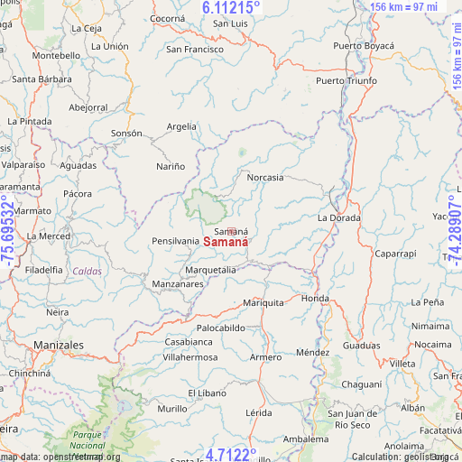
Samaná GPS coordinates[2]
5° 24' 45.288" North, 74° 59' 31.884" West
| Map corner | latitude | longitude |
|---|---|---|
| Upper-left | 6.11215°, | -75.69532° |
| Center: | 5.41258°, | -74.99219° |
| Lower-right: | 4.7122°, | -74.28907° |
| Map W x H: | 155.7×155.7 km | = 96.7×96.7mi |
| max Lat: | 13.38166° ⇑52% North |
| Samaná: | 5.41258° |
| min Lat: | ⇓48% South -4.21528° |
| min Long | Samaná | max Long |
| -81.70636° | -74.99219° | -67.06996° |
| W 46%⇐ | ⇒54% E |
Elevation
Elevation of Samaná is 1463 m = 4800 ft, and this is 313.7 m = 1029 ft above average elevation for this country.
| Max E: |
3342 m = 10965 ft | 39.8% |
| Samaná | 1463 m 4800 ft | |
| Avg. | 1149.3 m = 3771 ft | |
Min E: |
1 m = 3 ft | 60.2% |
See also: Colombia elevation on elevation.city.
Geographical zone
Samaná is located in North Torrid zone (between Equator and Tropic of Cancer). Distance of Equator is 601.8 km =373.9 mi to South.| Distance of | km | miles | from Samaná |
|---|---|---|---|
| North Pole | 9405.2 | 5844.1 | to North |
| Arctic Circle | 6799.4 | 4224.9 | to North |
| Tropic Cancer | 2004.1 | 1245.3 | to North |
| Equator | 601.8 | 373.9 | to South |


Nearby cities:
15 places around Samaná: (largest is in red/bold)
• Falan
32.4 km =20.1 mi,  172°
172°
• Fresno
29.3 km =18.2 mi,  189°
189°
• Honda
36.3 km =22.6 mi,  128°
128°
• La Dorada
36.6 km =22.7 mi,  83°
83°
• Manzanares
25.1 km =15.6 mi,  225°
225°
• Marquetalia
14.6 km =9.1 mi,  208°
208°
• Marulanda
32.9 km =20.4 mi,  244°
244°
• Nariño
29.9 km =18.6 mi,  316°
316°
• Norcasia
21.4 km =13.3 mi,  32°
32°
• Padua
35 km =21.7 mi, 207°
• Palocabildo
33 km =20.5 mi,  184°
184°
• Pensilvania
19 km =11.8 mi,  260°
260°
• Puerto Bogotá
37.7 km =23.4 mi, 128°
• San Sebastián de Mariquita
26.2 km =16.3 mi,  155°
155°
• Victoria
14 km =8.7 mi,  139°
139°
Sources, notices
• [Note1] Compared only with cities in Colombia existing in our database
• [Src1] Map data: © OpenStreetMap contributors (CC-BY-SA)
• [Src2] Other city data from geonames.org with taken over terms of usage.
• [Src3] Geographical zone / Annual Mean Temperature by Robert A. Rohde @ Wikipedia
