Honda geodata
Honda (Tolima) is a seat of a second-order administrative division; located in Colombia in America/Bogota (GMT-5) time zone. With population of 28,158 people, there are 129 cities with bigger population in this country. Compared to other cities in Colombia, 57.1% of cities are located further ↑North; 52.4% of cities are located further ←West and 74.4% of cities have higher elevation than Honda. Note1


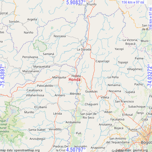
Honda GPS coordinates[2]
5° 12' 30.816" North, 74° 44' 9.024" West
| Map corner | latitude | longitude |
|---|---|---|
| Upper-left | 5.90837°, | -75.43897° |
| Center: | 5.20856°, | -74.73584° |
| Lower-right: | 4.50797°, | -74.03272° |
| Map W x H: | 155.7×155.7 km | = 96.7×96.7mi |
| max Lat: | 13.38166° ⇑57.1% North |
| Honda: | 5.20856° |
| min Lat: | ⇓42.9% South -4.21528° |
| min Long | Honda | max Long |
| -81.70636° | -74.73584° | -67.06996° |
| W 52.4%⇐ | ⇒47.6% E |
Elevation
Elevation of Honda is 200 m = 656 ft, and this is 949.3 m = 3115 ft below average elevation for this country.
| Max E: |
3342 m = 10965 ft | 74.4% |
| Avg. | 1149.3 m = 3771 ft | |
| Honda | 200 m = 656 ft | |
Min E: |
1 m = 3 ft | 25.6% |
See also: Colombia elevation on elevation.city.
Geographical zone
Honda is located in North Torrid zone (between Equator and Tropic of Cancer). Distance of Equator is 579.1 km =359.8 mi to South.| Distance of | km | miles | from Honda |
|---|---|---|---|
| North Pole | 9427.9 | 5858.2 | to North |
| Arctic Circle | 6822 | 4239 | to North |
| Tropic Cancer | 2026.8 | 1259.4 | to North |
| Equator | 579.1 | 359.8 | to South |


Nearby cities:
15 places around Honda: (largest is in red/bold)
• Armero-Guyabal
32.6 km =20.3 mi,  214°
214°
• Cachipay
19.8 km =12.3 mi,  70°
70°
• Caparrapí
31.1 km =19.3 mi,  60°
60°
• Falan
25.7 km =16 mi,  248°
248°
• Granada
24.5 km =15.2 mi,  130°
130°
• Guaduas
22.2 km =13.8 mi,  135°
135°
• Guayabal
25.9 km =16.1 mi,  220°
220°
• La Dorada
27.8 km =17.3 mi,  16°
16°
• Palocabildo
32.8 km =20.4 mi, 251°
• Puerto Bogotá
1.3 km =0.8 mi, 135°
• Puerto Salgar
29.7 km =18.5 mi, 17°
• Quebradanegra
30.1 km =18.7 mi,  109°
109°
• San Sebastián de Mariquita
17.4 km =10.8 mi,  266°
266°
• Victoria
22.8 km =14.2 mi,  301°
301°
• Útica
28.3 km =17.6 mi,  94°
94°
Sources, notices
• [Note1] Compared only with cities in Colombia existing in our database
• [Src1] Map data: © OpenStreetMap contributors (CC-BY-SA)
• [Src2] Other city data from geonames.org with taken over terms of usage.
• [Src3] Geographical zone / Annual Mean Temperature by Robert A. Rohde @ Wikipedia
