Padua geodata
Padua (Tolima) is a populated place; located in Colombia in America/Bogota (GMT-5) time zone. With population of 19,311 people, there are 186 cities with bigger population in this country. Compared to other cities in Colombia, 58.6% of cities are located further ↑North; 57.5% of cities are located further →East and 79.6% of cities have lower elevation than Padua. Note1


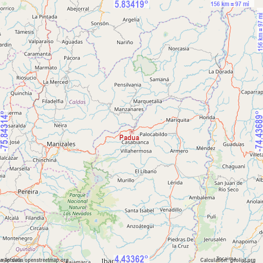
Padua GPS coordinates[2]
5° 8' 3.444" North, 75° 8' 24.036" West
| Map corner | latitude | longitude |
|---|---|---|
| Upper-left | 5.83419°, | -75.84314° |
| Center: | 5.13429°, | -75.14001° |
| Lower-right: | 4.43362°, | -74.43689° |
| Map W x H: | 155.7×155.7 km | = 96.7×96.7mi |
| max Lat: | 13.38166° ⇑58.6% North |
| Padua: | 5.13429° |
| min Lat: | ⇓41.4% South -4.21528° |
| min Long | Padua | max Long |
| -81.70636° | -75.14001° | -67.06996° |
| W 42.5%⇐ | ⇒57.5% E |
Elevation
Elevation of Padua is 2041 m = 6696 ft, and this is 891.7 m = 2926 ft above average elevation for this country.
| Max E: |
3342 m = 10965 ft | 20.4% |
| Padua | 2041 m 6696 ft | |
| Avg. | 1149.3 m = 3771 ft | |
Min E: |
1 m = 3 ft | 79.6% |
See also: Colombia elevation on elevation.city.
Geographical zone
Padua is located in North Torrid zone (between Equator and Tropic of Cancer). Distance of Equator is 570.9 km =354.7 mi to South.| Distance of | km | miles | from Padua |
|---|---|---|---|
| North Pole | 9436.2 | 5863.4 | to North |
| Arctic Circle | 6830.3 | 4244.2 | to North |
| Tropic Cancer | 2035 | 1264.5 | to North |
| Equator | 570.9 | 354.7 | to South |


Nearby cities:
15 places around Padua: (largest is in red/bold)
• Casabianca
6.5 km =4 mi,  160°
160°
• Falan
20.9 km =13 mi,  93°
93°
• Fresno
11.7 km =7.3 mi,  79°
79°
• Frías
18.6 km =11.6 mi,  128°
128°
• Guayabal
30.3 km =18.8 mi,  112°
112°
• Herveo
7.2 km =4.5 mi,  213°
213°
• Líbano
25.1 km =15.6 mi, 159°
• Manzanares
13.4 km =8.3 mi,  353°
353°
• Marquetalia
20.4 km =12.7 mi,  27°
27°
• Marulanda
21.3 km =13.2 mi,  321°
321°
• Murillo
29.2 km =18.1 mi,  186°
186°
• Palocabildo
13.7 km =8.5 mi,  98°
98°
• Pensilvania
27.8 km =17.3 mi,  355°
355°
• San Sebastián de Mariquita
28.3 km =17.6 mi, 75°
• Villahermosa
11.8 km =7.3 mi,  167°
167°
Sources, notices
• [Note1] Compared only with cities in Colombia existing in our database
• [Src1] Map data: © OpenStreetMap contributors (CC-BY-SA)
• [Src2] Other city data from geonames.org with taken over terms of usage.
• [Src3] Geographical zone / Annual Mean Temperature by Robert A. Rohde @ Wikipedia
