Puerto Bogotá geodata
Puerto Bogotá (Cundinamarca) is a populated place; located in Colombia in America/Bogota (GMT-5) time zone. With population of 1,200 people, there are 917 cities with bigger population in this country. Compared to other cities in Colombia, 57.3% of cities are located further ↑North; 52.5% of cities are located further ←West and 73.3% of cities have higher elevation than Puerto Bogotá. Note1


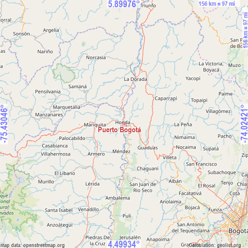
Puerto Bogotá GPS coordinates[2]
5° 11' 59.784" North, 74° 43' 38.388" West
| Map corner | latitude | longitude |
|---|---|---|
| Upper-left | 5.89976°, | -75.43046° |
| Center: | 5.19994°, | -74.72733° |
| Lower-right: | 4.49934°, | -74.02421° |
| Map W x H: | 155.7×155.7 km | = 96.7×96.7mi |
| max Lat: | 13.38166° ⇑57.3% North |
| Puerto Bogotá: | 5.19994° |
| min Lat: | ⇓42.7% South -4.21528° |
| min Long | Puerto Bogotá | max Long |
| -81.70636° | -74.72733° | -67.06996° |
| W 52.5%⇐ | ⇒47.5% E |
Elevation
Elevation of Puerto Bogotá is 225 m = 738 ft, and this is 924.3 m = 3032 ft below average elevation for this country.
| Max E: |
3342 m = 10965 ft | 73.3% |
| Avg. | 1149.3 m = 3771 ft | |
| Puerto Bogotá | 225 m = 738 ft | |
Min E: |
1 m = 3 ft | 26.7% |
See also: Colombia elevation on elevation.city.
Geographical zone
Puerto Bogotá is located in North Torrid zone (between Equator and Tropic of Cancer). Distance of Equator is 578.2 km =359.3 mi to South.| Distance of | km | miles | from Puerto Bogotá |
|---|---|---|---|
| North Pole | 9428.9 | 5858.8 | to North |
| Arctic Circle | 6823 | 4239.6 | to North |
| Tropic Cancer | 2027.7 | 1260 | to North |
| Equator | 578.2 | 359.3 | to South |


Nearby cities:
15 places around Puerto Bogotá: (largest is in red/bold)
• Armero-Guyabal
32.4 km =20.1 mi,  216°
216°
• Cachipay
19.3 km =12 mi,  67°
67°
• Caparrapí
30.8 km =19.1 mi,  58°
58°
• Chaguaní
31.6 km =19.6 mi,  152°
152°
• Falan
26.3 km =16.3 mi,  251°
251°
• Granada
23.2 km =14.4 mi,  129°
129°
• Guaduas
20.8 km =12.9 mi,  135°
135°
• Guayabal
25.8 km =16 mi, 223°
• Honda
1.3 km =0.8 mi,  315°
315°
• La Dorada
28.5 km =17.7 mi,  14°
14°
• Puerto Salgar
30.3 km =18.8 mi,  15°
15°
• Quebradanegra
28.9 km =18 mi,  108°
108°
• San Sebastián de Mariquita
18.3 km =11.4 mi,  269°
269°
• Victoria
24.1 km =15 mi,  302°
302°
• Útica
27.3 km =17 mi,  92°
92°
Sources, notices
• [Note1] Compared only with cities in Colombia existing in our database
• [Src1] Map data: © OpenStreetMap contributors (CC-BY-SA)
• [Src2] Other city data from geonames.org with taken over terms of usage.
• [Src3] Geographical zone / Annual Mean Temperature by Robert A. Rohde @ Wikipedia
