Parrita geodata
Parrita (Puntarenas) is a populated place; located in Costa Rica in America/Costa_Rica (GMT-6) time zone. With population of 3,734 people, there are 89 cities with bigger population in this country. Compared to other cities in Costa Rica, 91.8% of cities are located further ↑North; 67.9% of cities are located further →East and 92.5% of cities have higher elevation than Parrita. Note1


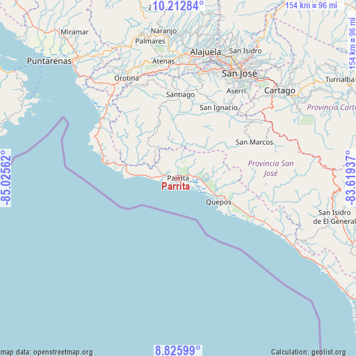
Parrita GPS coordinates[2]
9° 31' 12.432" North, 84° 19' 20.964" West
| Map corner | latitude | longitude |
|---|---|---|
| Upper-left | 10.21284°, | -85.02562° |
| Center: | 9.52012°, | -84.32249° |
| Lower-right: | 8.82599°, | -83.61937° |
| Map W x H: | 154.2×154.2 km | = 95.8×95.8mi |
| max Lat: | 11.07377° ⇑91.8% North |
| Parrita: | 9.52012° |
| min Lat: | ⇓8.2% South 8.53305° |
| min Long | Parrita | max Long |
| -85.64748° | -84.32249° | -82.62185° |
| W 32.1%⇐ | ⇒67.9% E |
Elevation
Elevation of Parrita is 12 m = 39 ft, and this is 723 m = 2372 ft below average elevation for this country.
| Max E: |
1844 m = 6050 ft | 92.5% |
| Avg. | 735 m = 2411 ft | |
| Parrita | 12 m = 39 ft | |
Min E: |
7 m = 23 ft | 7.5% |
See also: Costa Rica elevation on elevation.city.
Geographical zone
Parrita is located in North Torrid zone (between Equator and Tropic of Cancer). Distance of Equator is 1058.5 km =657.7 mi to South.| Distance of | km | miles | from Parrita |
|---|---|---|---|
| North Pole | 8948.5 | 5560.3 | to North |
| Arctic Circle | 6342.6 | 3941.1 | to North |
| Tropic Cancer | 1547.4 | 961.5 | to North |
| Equator | 1058.5 | 657.7 | to South |


Nearby cities:
15 places around Parrita: (largest is in red/bold)
• Aserrí
45.3 km =28.1 mi,  33°
33°
• Colón
44.8 km =27.8 mi,  11°
11°
• Jacó
35.3 km =21.9 mi,  287°
287°
• Monterrey
35.2 km =21.9 mi,  41°
41°
• Pacayas
43.9 km =27.3 mi, 43°
• Palmichal
37.6 km =23.4 mi,  20°
20°
• Quepos
20.2 km =12.6 mi,  119°
119°
• Salitral
46.3 km =28.8 mi, 19°
• Salitrillos
44.9 km =27.9 mi, 34°
• San Ignacio
35.6 km =22.1 mi, 29°
• San Marcos
36.6 km =22.7 mi,  64°
64°
• San Pablo
35.8 km =22.2 mi, 59°
• San Rafael Abajo
34.7 km =21.6 mi, 5°
• Santiago
36.3 km =22.6 mi,  1°
1°
• Tejar
27 km =16.8 mi, 21°
Sources, notices
• [Note1] Compared only with cities in Costa Rica existing in our database
• [Src1] Map data: © OpenStreetMap contributors (CC-BY-SA)
• [Src2] Other city data from geonames.org with taken over terms of usage.
• [Src3] Geographical zone / Annual Mean Temperature by Robert A. Rohde @ Wikipedia
