Colón geodata
Colón (San José) is a populated place; located in Costa Rica in America/Costa_Rica (GMT-6) time zone. With population of 9,687 people, there are 56 cities with bigger population in this country. Compared to other cities in Costa Rica, 63.4% of cities are located further ↑North; 62.7% of cities are located further →East and 52.2% of cities have higher elevation than Colón. Note1


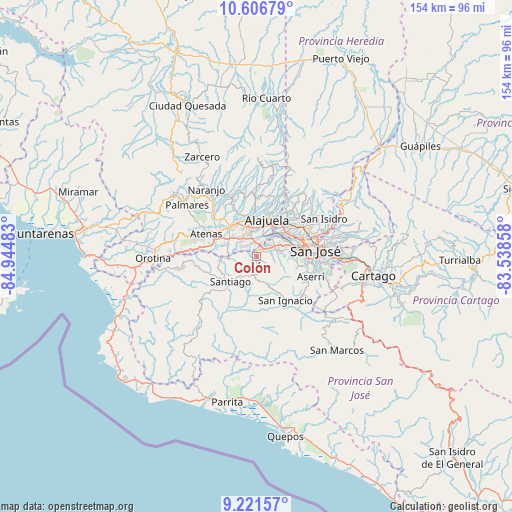
Colón GPS coordinates[2]
9° 54' 53.676" North, 84° 14' 30.12" West
| Map corner | latitude | longitude |
|---|---|---|
| Upper-left | 10.60679°, | -84.94483° |
| Center: | 9.91491°, | -84.2417° |
| Lower-right: | 9.22157°, | -83.53858° |
| Map W x H: | 154×154 km | = 95.7×95.7mi |
| max Lat: | 11.07377° ⇑63.4% North |
| Colón: | 9.91491° |
| min Lat: | ⇓36.6% South 8.53305° |
| min Long | Colón | max Long |
| -85.64748° | -84.2417° | -82.62185° |
| W 37.3%⇐ | ⇒62.7% E |
Elevation
Elevation of Colón is 801 m = 2628 ft, and this is 66 m = 217 ft above average elevation for this country.
| Max E: |
1844 m = 6050 ft | 52.2% |
| Colón | 801 m 2628 ft | |
| Avg. | 735 m = 2411 ft | |
Min E: |
7 m = 23 ft | 47.8% |
See also: Costa Rica elevation on elevation.city.
Geographical zone
Colón is located in North Torrid zone (between Equator and Tropic of Cancer). Distance of Equator is 1102.4 km =685 mi to South.| Distance of | km | miles | from Colón |
|---|---|---|---|
| North Pole | 8904.6 | 5533.1 | to North |
| Arctic Circle | 6298.7 | 3913.8 | to North |
| Tropic Cancer | 1503.5 | 934.2 | to North |
| Equator | 1102.4 | 685 | to South |


Nearby cities:
15 places around Colón: (largest is in red/bold)
• Alajuela
11.7 km =7.3 mi,  16°
16°
• Alajuelita
15.5 km =9.6 mi,  95°
95°
• Carrillos
13.2 km =8.2 mi,  344°
344°
• Escazú
11.2 km =7 mi,  87°
87°
• La Asunción
10.4 km =6.5 mi,  46°
46°
• Llorente
13.3 km =8.3 mi, 45°
• Palmichal
9.5 km =5.9 mi,  154°
154°
• Salitral
6.9 km =4.3 mi, 93°
• San Antonio
9.9 km =6.2 mi,  40°
40°
• San Felipe
15 km =9.3 mi, 94°
• San Francisco
15.1 km =9.4 mi, 54°
• San Rafael
11.5 km =7.1 mi,  82°
82°
• San Rafael Abajo
10.7 km =6.6 mi,  209°
209°
• Santa Ana
6.8 km =4.2 mi,  73°
73°
• Santiago
11 km =6.8 mi,  226°
226°
Sources, notices
• [Note1] Compared only with cities in Costa Rica existing in our database
• [Src1] Map data: © OpenStreetMap contributors (CC-BY-SA)
• [Src2] Other city data from geonames.org with taken over terms of usage.
• [Src3] Geographical zone / Annual Mean Temperature by Robert A. Rohde @ Wikipedia
