Jacó geodata
Jacó (Puntarenas) is a seat of a second-order administrative division; located in Costa Rica in America/Costa_Rica (GMT-6) time zone. With population of 4,085 people, there are 85 cities with bigger population in this country. Compared to other cities in Costa Rica, 90.3% of cities are located further ↑North; 79.9% of cities are located further →East and 96.3% of cities have higher elevation than Jacó. Note1


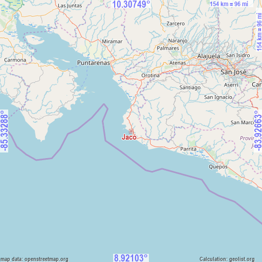
Jacó GPS coordinates[2]
9° 36' 53.892" North, 84° 37' 47.1" West
| Map corner | latitude | longitude |
|---|---|---|
| Upper-left | 10.30749°, | -85.33288° |
| Center: | 9.61497°, | -84.62975° |
| Lower-right: | 8.92103°, | -83.92663° |
| Map W x H: | 154.2×154.2 km | = 95.8×95.8mi |
| max Lat: | 11.07377° ⇑90.3% North |
| Jacó: | 9.61497° |
| min Lat: | ⇓9.7% South 8.53305° |
| min Long | Jacó | max Long |
| -85.64748° | -84.62975° | -82.62185° |
| W 20.1%⇐ | ⇒79.9% E |
Elevation
Elevation of Jacó is 10 m = 33 ft, and this is 725 m = 2379 ft below average elevation for this country.
| Max E: |
1844 m = 6050 ft | 96.3% |
| Avg. | 735 m = 2411 ft | |
| Jacó | 10 m = 33 ft | |
Min E: |
7 m = 23 ft | 3.7% |
See also: Costa Rica elevation on elevation.city.
Geographical zone
Jacó is located in North Torrid zone (between Equator and Tropic of Cancer). Distance of Equator is 1069.1 km =664.3 mi to South.| Distance of | km | miles | from Jacó |
|---|---|---|---|
| North Pole | 8938 | 5553.8 | to North |
| Arctic Circle | 6332.1 | 3934.6 | to North |
| Tropic Cancer | 1536.8 | 954.9 | to North |
| Equator | 1069.1 | 664.3 | to South |


Nearby cities:
15 places around Jacó: (largest is in red/bold)
• Atenas
48.6 km =30.2 mi,  34°
34°
• Barrio Jesús
46 km =28.6 mi, 29°
• Chacarita
44.2 km =27.5 mi,  338°
338°
• Desamparados
39.3 km =24.4 mi,  20°
20°
• Esparza
42.4 km =26.3 mi,  354°
354°
• Macacona
43.1 km =26.8 mi,  358°
358°
• Orotina
35 km =21.7 mi, 19°
• Paquera
40.5 km =25.2 mi,  304°
304°
• Parrita
35.3 km =21.9 mi,  107°
107°
• Puntarenas
46.2 km =28.7 mi,  330°
330°
• San Rafael
52.8 km =32.8 mi, 19°
• San Rafael Abajo
44.3 km =27.5 mi,  57°
57°
• Santiago
43.1 km =26.8 mi,  53°
53°
• Santiago
49.7 km =30.9 mi, 24°
• Tejar
45.8 km =28.5 mi,  71°
71°
Sources, notices
• [Note1] Compared only with cities in Costa Rica existing in our database
• [Src1] Map data: © OpenStreetMap contributors (CC-BY-SA)
• [Src2] Other city data from geonames.org with taken over terms of usage.
• [Src3] Geographical zone / Annual Mean Temperature by Robert A. Rohde @ Wikipedia
