Orotina geodata
Orotina (Alajuela) is a populated place; located in Costa Rica in America/Costa_Rica (GMT-6) time zone. With population of 6,135 people, there are 70 cities with bigger population in this country. Compared to other cities in Costa Rica, 64.2% of cities are located further ↑North; 78.4% of cities are located further →East and 70.9% of cities have higher elevation than Orotina. Note1


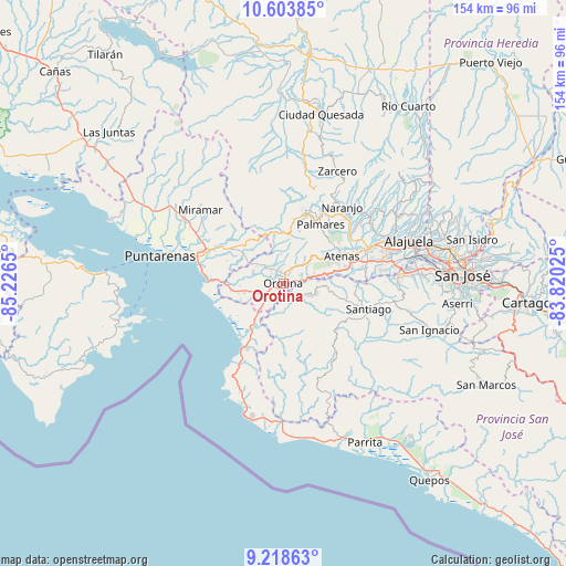
Orotina GPS coordinates[2]
9° 54' 43.092" North, 84° 31' 24.132" West
| Map corner | latitude | longitude |
|---|---|---|
| Upper-left | 10.60385°, | -85.2265° |
| Center: | 9.91197°, | -84.52337° |
| Lower-right: | 9.21863°, | -83.82025° |
| Map W x H: | 154×154 km | = 95.7×95.7mi |
| max Lat: | 11.07377° ⇑64.2% North |
| Orotina: | 9.91197° |
| min Lat: | ⇓35.8% South 8.53305° |
| min Long | Orotina | max Long |
| -85.64748° | -84.52337° | -82.62185° |
| W 21.6%⇐ | ⇒78.4% E |
Elevation
Elevation of Orotina is 237 m = 778 ft, and this is 498 m = 1634 ft below average elevation for this country.
| Max E: |
1844 m = 6050 ft | 70.9% |
| Avg. | 735 m = 2411 ft | |
| Orotina | 237 m = 778 ft | |
Min E: |
7 m = 23 ft | 29.1% |
See also: Costa Rica elevation on elevation.city.
Geographical zone
Orotina is located in North Torrid zone (between Equator and Tropic of Cancer). Distance of Equator is 1102.1 km =684.8 mi to South.| Distance of | km | miles | from Orotina |
|---|---|---|---|
| North Pole | 8905 | 5533.3 | to North |
| Arctic Circle | 6299.1 | 3914.1 | to North |
| Tropic Cancer | 1503.8 | 934.4 | to North |
| Equator | 1102.1 | 684.8 | to South |


Nearby cities:
15 places around Orotina: (largest is in red/bold)
• Atenas
17.3 km =10.7 mi,  66°
66°
• Barrio Jesús
13.1 km =8.1 mi,  58°
58°
• Chacarita
29.1 km =18.1 mi,  286°
286°
• Desamparados
4.3 km =2.7 mi,  25°
25°
• Esparza
18 km =11.2 mi,  300°
300°
• Esquipulas
19.5 km =12.1 mi, 34°
• Macacona
16.3 km =10.1 mi,  308°
308°
• Miramar
30.2 km =18.8 mi, 311°
• Naranjo
26.1 km =16.2 mi,  37°
37°
• San Rafael
17.8 km =11.1 mi,  18°
18°
• San Rafael Abajo
27.1 km =16.8 mi,  109°
109°
• San Ramón
20.4 km =12.7 mi, 16°
• Santiago
15.1 km =9.4 mi, 35°
• Santiago
24 km =14.9 mi, 107°
• Sarchí
27.6 km =17.1 mi, 44°
Sources, notices
• [Note1] Compared only with cities in Costa Rica existing in our database
• [Src1] Map data: © OpenStreetMap contributors (CC-BY-SA)
• [Src2] Other city data from geonames.org with taken over terms of usage.
• [Src3] Geographical zone / Annual Mean Temperature by Robert A. Rohde @ Wikipedia
