Macacona geodata
Macacona (Puntarenas) is a populated place; located in Costa Rica in America/Costa_Rica (GMT-6) time zone. With population of 840 people, there are 121 cities with bigger population in this country. Compared to other cities in Costa Rica, 61.2% of cities are located further ↓South; 80.6% of cities are located further →East and 67.9% of cities have higher elevation than Macacona. Note1


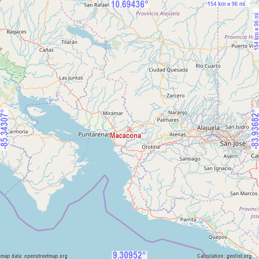
Macacona GPS coordinates[2]
10° 0' 9.648" North, 84° 38' 23.784" West
| Map corner | latitude | longitude |
|---|---|---|
| Upper-left | 10.69436°, | -85.34307° |
| Center: | 10.00268°, | -84.63994° |
| Lower-right: | 9.30952°, | -83.93682° |
| Map W x H: | 154×154 km | = 95.7×95.7mi |
| max Lat: | 11.07377° ⇑38.8% North |
| Macacona: | 10.00268° |
| min Lat: | ⇓61.2% South 8.53305° |
| min Long | Macacona | max Long |
| -85.64748° | -84.63994° | -82.62185° |
| W 19.4%⇐ | ⇒80.6% E |
Elevation
Elevation of Macacona is 259 m = 850 ft, and this is 476 m = 1562 ft below average elevation for this country.
| Max E: |
1844 m = 6050 ft | 67.9% |
| Avg. | 735 m = 2411 ft | |
| Macacona | 259 m = 850 ft | |
Min E: |
7 m = 23 ft | 32.1% |
See also: Costa Rica elevation on elevation.city.
Geographical zone
Macacona is located in North Torrid zone (between Equator and Tropic of Cancer). Distance of Equator is 1112.2 km =691.1 mi to South.| Distance of | km | miles | from Macacona |
|---|---|---|---|
| North Pole | 8894.9 | 5527 | to North |
| Arctic Circle | 6289 | 3907.8 | to North |
| Tropic Cancer | 1493.7 | 928.1 | to North |
| Equator | 1112.2 | 691.1 | to South |


Nearby cities:
15 places around Macacona: (largest is in red/bold)
• Atenas
28.8 km =17.9 mi,  96°
96°
• Barrio Jesús
24.1 km =15 mi, 97°
• Chacarita
15.4 km =9.6 mi,  262°
262°
• Desamparados
15.9 km =9.9 mi,  112°
112°
• Esparza
2.9 km =1.8 mi,  251°
251°
• Esquipulas
24.5 km =15.2 mi,  75°
75°
• Miramar
14 km =8.7 mi,  315°
315°
• Naranjo
30.6 km =19 mi,  69°
69°
• Orotina
16.3 km =10.1 mi,  128°
128°
• Puntarenas
21.9 km =13.6 mi, 262°
• San Rafael
19.5 km =12.1 mi, 69°
• San Ramón
20.9 km =13 mi,  62°
62°
• Santiago
21.5 km =13.4 mi, 84°
• Sarchí
33.4 km =20.8 mi, 73°
• Zarcero
34 km =21.1 mi,  53°
53°
Sources, notices
• [Note1] Compared only with cities in Costa Rica existing in our database
• [Src1] Map data: © OpenStreetMap contributors (CC-BY-SA)
• [Src2] Other city data from geonames.org with taken over terms of usage.
• [Src3] Geographical zone / Annual Mean Temperature by Robert A. Rohde @ Wikipedia
