San Ramón geodata
San Ramón (Alajuela) is a populated place; located in Costa Rica in America/Costa_Rica (GMT-6) time zone. With population of 10,765 people, there are 52 cities with bigger population in this country. Compared to other cities in Costa Rica, 72.4% of cities are located further ↓South; 75.4% of cities are located further →East and 61.9% of cities have lower elevation than San Ramón. Note1


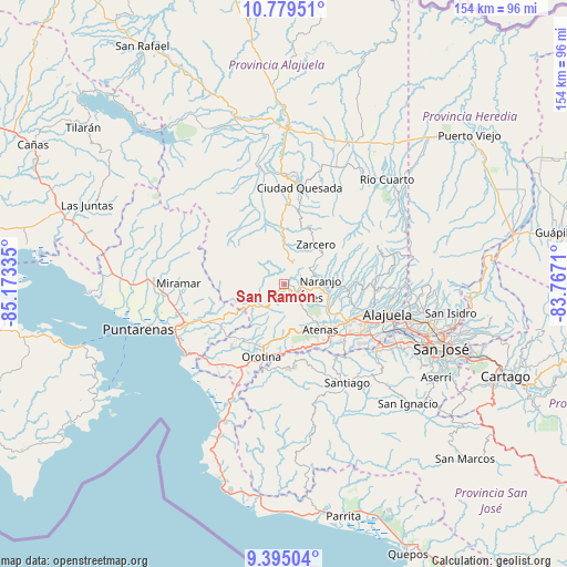
San Ramón GPS coordinates[2]
10° 5' 16.872" North, 84° 28' 12.792" West
| Map corner | latitude | longitude |
|---|---|---|
| Upper-left | 10.77951°, | -85.17335° |
| Center: | 10.08802°, | -84.47022° |
| Lower-right: | 9.39504°, | -83.7671° |
| Map W x H: | 153.9×153.9 km | = 95.6×95.6mi |
| max Lat: | 11.07377° ⇑27.6% North |
| San Ramón: | 10.08802° |
| min Lat: | ⇓72.4% South 8.53305° |
| min Long | San Ramón | max Long |
| -85.64748° | -84.47022° | -82.62185° |
| W 24.6%⇐ | ⇒75.4% E |
Elevation
Elevation of San Ramón is 1061 m = 3481 ft, and this is 326 m = 1070 ft above average elevation for this country.
| Max E: |
1844 m = 6050 ft | 38.1% |
| San Ramón | 1061 m 3481 ft | |
| Avg. | 735 m = 2411 ft | |
Min E: |
7 m = 23 ft | 61.9% |
See also: Costa Rica elevation on elevation.city.
Geographical zone
San Ramón is located in North Torrid zone (between Equator and Tropic of Cancer). Distance of Equator is 1121.7 km =697 mi to South.| Distance of | km | miles | from San Ramón |
|---|---|---|---|
| North Pole | 8885.4 | 5521.1 | to North |
| Arctic Circle | 6279.5 | 3901.9 | to North |
| Tropic Cancer | 1484.2 | 922.2 | to North |
| Equator | 1121.7 | 697 | to South |


Nearby cities:
15 places around San Ramón: (largest is in red/bold)
• Atenas
16.1 km =10 mi,  141°
141°
• Barrio Jesús
13.7 km =8.5 mi,  157°
157°
• Carrillos
22.5 km =14 mi,  106°
106°
• Desamparados
16.1 km =10 mi,  194°
194°
• Esparza
23.7 km =14.7 mi,  243°
243°
• Esquipulas
6.2 km =3.9 mi,  124°
124°
• Laguna
15.5 km =9.6 mi,  29°
29°
• Macacona
20.9 km =13 mi, 242°
• Naranjo
10.1 km =6.3 mi,  83°
83°
• Orotina
20.4 km =12.7 mi,  196°
196°
• San Juan
16.9 km =10.5 mi, 84°
• San Rafael
2.7 km =1.7 mi, 186°
• Santiago
7.8 km =4.8 mi, 158°
• Sarchí
13.4 km =8.3 mi,  89°
89°
• Zarcero
13.9 km =8.6 mi,  38°
38°
Sources, notices
• [Note1] Compared only with cities in Costa Rica existing in our database
• [Src1] Map data: © OpenStreetMap contributors (CC-BY-SA)
• [Src2] Other city data from geonames.org with taken over terms of usage.
• [Src3] Geographical zone / Annual Mean Temperature by Robert A. Rohde @ Wikipedia
