Barrio Jesús geodata
Barrio Jesús (Alajuela) is a seat of a third-order administrative division; located in Costa Rica in America/Costa_Rica (GMT-6) time zone. In our database, there are 124 cities with bigger population. Compared to other cities in Costa Rica, 50.7% of cities are located further ↓South; 72.4% of cities are located further →East and 50% of cities have lower elevation than Barrio Jesús. Note1


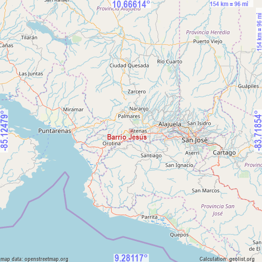
Barrio Jesús GPS coordinates[2]
9° 58' 27.804" North, 84° 25' 17.976" West
| Map corner | latitude | longitude |
|---|---|---|
| Upper-left | 10.66614°, | -85.12479° |
| Center: | 9.97439°, | -84.42166° |
| Lower-right: | 9.28117°, | -83.71854° |
| Map W x H: | 154×154 km | = 95.7×95.7mi |
| max Lat: | 11.07377° ⇑49.3% North |
| Barrio Jesús: | 9.97439° |
| min Lat: | ⇓50.7% South 8.53305° |
| min Long | Barrio Jesús | max Long |
| -85.64748° | -84.42166° | -82.62185° |
| W 27.6%⇐ | ⇒72.4% E |
Elevation
Elevation of Barrio Jesús is 884 m = 2900 ft, and this is 149 m = 489 ft above average elevation for this country.
| Max E: |
1844 m = 6050 ft | 50% |
| Barrio Jesús | 884 m 2900 ft | |
| Avg. | 735 m = 2411 ft | |
Min E: |
7 m = 23 ft | 50% |
See also: Costa Rica elevation on elevation.city.
Geographical zone
Barrio Jesús is located in North Torrid zone (between Equator and Tropic of Cancer). Distance of Equator is 1109 km =689.1 mi to South.| Distance of | km | miles | from Barrio Jesús |
|---|---|---|---|
| North Pole | 8898 | 5529 | to North |
| Arctic Circle | 6292.1 | 3909.7 | to North |
| Tropic Cancer | 1496.9 | 930.1 | to North |
| Equator | 1109 | 689.1 | to South |


Nearby cities:
15 places around Barrio Jesús: (largest is in red/bold)
• Alajuela
23.5 km =14.6 mi,  78°
78°
• Atenas
4.7 km =2.9 mi,  89°
89°
• Carrillos
17.3 km =10.7 mi,  69°
69°
• Colón
20.8 km =12.9 mi,  108°
108°
• Desamparados
9.7 km =6 mi,  251°
251°
• Esquipulas
9.2 km =5.7 mi,  358°
358°
• Naranjo
14.6 km =9.1 mi,  18°
18°
• Orotina
13.1 km =8.1 mi,  238°
238°
• San Juan
18.3 km =11.4 mi,  38°
38°
• San Rafael
11.4 km =7.1 mi,  330°
330°
• San Rafael Abajo
21.5 km =13.4 mi,  137°
137°
• San Ramón
13.7 km =8.5 mi,  337°
337°
• Santiago
5.9 km =3.7 mi, 335°
• Santiago
18.5 km =11.5 mi, 140°
• Sarchí
15.2 km =9.4 mi,  32°
32°
Sources, notices
• [Note1] Compared only with cities in Costa Rica existing in our database
• [Src1] Map data: © OpenStreetMap contributors (CC-BY-SA)
• [Src2] Other city data from geonames.org with taken over terms of usage.
• [Src3] Geographical zone / Annual Mean Temperature by Robert A. Rohde @ Wikipedia
