San Rafael geodata
San Rafael (Alajuela) is a populated place; located in Costa Rica in America/Costa_Rica (GMT-6) time zone. With population of 3,624 people, there are 90 cities with bigger population in this country. Compared to other cities in Costa Rica, 69.4% of cities are located further ↓South; 76.1% of cities are located further →East and 62.7% of cities have lower elevation than San Rafael. Note1


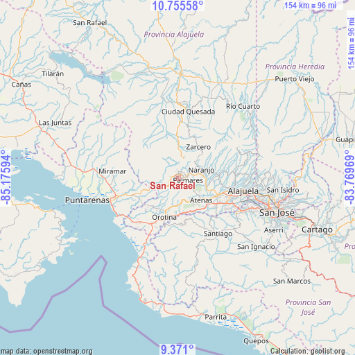
San Rafael GPS coordinates[2]
10° 3' 50.508" North, 84° 28' 22.116" West
| Map corner | latitude | longitude |
|---|---|---|
| Upper-left | 10.75558°, | -85.17594° |
| Center: | 10.06403°, | -84.47281° |
| Lower-right: | 9.371°, | -83.76969° |
| Map W x H: | 154×154 km | = 95.7×95.7mi |
| max Lat: | 11.07377° ⇑30.6% North |
| San Rafael: | 10.06403° |
| min Lat: | ⇓69.4% South 8.53305° |
| min Long | San Rafael | max Long |
| -85.64748° | -84.47281° | -82.62185° |
| W 23.9%⇐ | ⇒76.1% E |
Elevation
Elevation of San Rafael is 1074 m = 3524 ft, and this is 339 m = 1112 ft above average elevation for this country.
| Max E: |
1844 m = 6050 ft | 37.3% |
| San Rafael | 1074 m 3524 ft | |
| Avg. | 735 m = 2411 ft | |
Min E: |
7 m = 23 ft | 62.7% |
See also: Costa Rica elevation on elevation.city.
Geographical zone
San Rafael is located in North Torrid zone (between Equator and Tropic of Cancer). Distance of Equator is 1119 km =695.3 mi to South.| Distance of | km | miles | from San Rafael |
|---|---|---|---|
| North Pole | 8888 | 5522.7 | to North |
| Arctic Circle | 6282.2 | 3903.6 | to North |
| Tropic Cancer | 1486.9 | 923.9 | to North |
| Equator | 1119 | 695.3 | to South |


Nearby cities:
15 places around San Rafael: (largest is in red/bold)
• Atenas
14.3 km =8.9 mi,  133°
133°
• Barrio Jesús
11.4 km =7.1 mi,  150°
150°
• Carrillos
22.1 km =13.7 mi,  100°
100°
• Desamparados
13.5 km =8.4 mi,  195°
195°
• Esparza
22.4 km =13.9 mi,  249°
249°
• Esquipulas
5.5 km =3.4 mi, 98°
• Laguna
18 km =11.2 mi,  25°
25°
• Macacona
19.5 km =12.1 mi, 249°
• Naranjo
11 km =6.8 mi,  69°
69°
• Orotina
17.8 km =11.1 mi, 198°
• San Juan
17.6 km =10.9 mi,  75°
75°
• San Ramón
2.7 km =1.7 mi,  6°
6°
• Santiago
5.6 km =3.5 mi, 145°
• Sarchí
14 km =8.7 mi, 78°
• Zarcero
16.2 km =10.1 mi, 33°
Sources, notices
• [Note1] Compared only with cities in Costa Rica existing in our database
• [Src1] Map data: © OpenStreetMap contributors (CC-BY-SA)
• [Src2] Other city data from geonames.org with taken over terms of usage.
• [Src3] Geographical zone / Annual Mean Temperature by Robert A. Rohde @ Wikipedia
