Naranjo geodata
Naranjo (Alajuela) is a populated place; located in Costa Rica in America/Costa_Rica (GMT-6) time zone. With population of 11,853 people, there are 49 cities with bigger population in this country. Compared to other cities in Costa Rica, 75.4% of cities are located further ↓South; 69.4% of cities are located further →East and 59.7% of cities have lower elevation than Naranjo. Note1


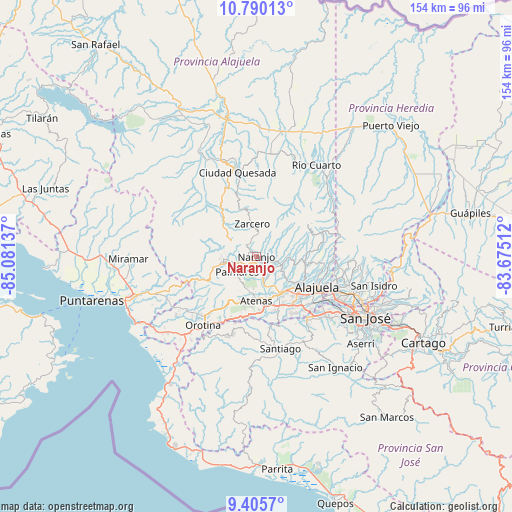
Naranjo GPS coordinates[2]
10° 5' 55.176" North, 84° 22' 41.664" West
| Map corner | latitude | longitude |
|---|---|---|
| Upper-left | 10.79013°, | -85.08137° |
| Center: | 10.09866°, | -84.37824° |
| Lower-right: | 9.4057°, | -83.67512° |
| Map W x H: | 153.9×153.9 km | = 95.6×95.6mi |
| max Lat: | 11.07377° ⇑24.6% North |
| Naranjo: | 10.09866° |
| min Lat: | ⇓75.4% South 8.53305° |
| min Long | Naranjo | max Long |
| -85.64748° | -84.37824° | -82.62185° |
| W 30.6%⇐ | ⇒69.4% E |
Elevation
Elevation of Naranjo is 1044 m = 3425 ft, and this is 309 m = 1014 ft above average elevation for this country.
| Max E: |
1844 m = 6050 ft | 40.3% |
| Naranjo | 1044 m 3425 ft | |
| Avg. | 735 m = 2411 ft | |
Min E: |
7 m = 23 ft | 59.7% |
See also: Costa Rica elevation on elevation.city.
Geographical zone
Naranjo is located in North Torrid zone (between Equator and Tropic of Cancer). Distance of Equator is 1122.9 km =697.7 mi to South.| Distance of | km | miles | from Naranjo |
|---|---|---|---|
| North Pole | 8884.2 | 5520.4 | to North |
| Arctic Circle | 6278.3 | 3901.2 | to North |
| Tropic Cancer | 1483.1 | 921.6 | to North |
| Equator | 1122.9 | 697.7 | to South |


Nearby cities:
15 places around Naranjo: (largest is in red/bold)
• Alajuela
20.4 km =12.7 mi,  116°
116°
• Atenas
13.8 km =8.6 mi,  180°
180°
• Barrio Jesús
14.6 km =9.1 mi,  198°
198°
• Carrillos
13.8 km =8.6 mi, 124°
• Desamparados
21.9 km =13.6 mi,  219°
219°
• Esquipulas
6.8 km =4.2 mi,  226°
226°
• Laguna
12.6 km =7.8 mi,  348°
348°
• Río Segundo
19.2 km =11.9 mi,  34°
34°
• Sabanilla
18 km =11.2 mi,  98°
98°
• San Juan
6.7 km =4.2 mi,  86°
86°
• San Rafael
11 km =6.8 mi,  249°
249°
• San Ramón
10.1 km =6.3 mi,  263°
263°
• Santiago
11.1 km =6.9 mi, 220°
• Sarchí
3.5 km =2.2 mi,  106°
106°
• Zarcero
9.8 km =6.1 mi, 351°
Sources, notices
• [Note1] Compared only with cities in Costa Rica existing in our database
• [Src1] Map data: © OpenStreetMap contributors (CC-BY-SA)
• [Src2] Other city data from geonames.org with taken over terms of usage.
• [Src3] Geographical zone / Annual Mean Temperature by Robert A. Rohde @ Wikipedia
