Atenas geodata
Atenas (Alajuela) is a populated place; located in Costa Rica in America/Costa_Rica (GMT-6) time zone. With population of 7,014 people, there are 65 cities with bigger population in this country. Compared to other cities in Costa Rica, 51.5% of cities are located further ↓South; 70.1% of cities are located further →East and 54.5% of cities have higher elevation than Atenas. Note1


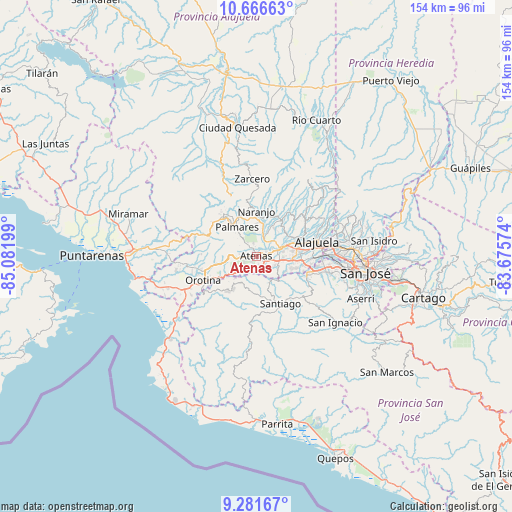
Atenas GPS coordinates[2]
9° 58' 29.604" North, 84° 22' 43.896" West
| Map corner | latitude | longitude |
|---|---|---|
| Upper-left | 10.66663°, | -85.08199° |
| Center: | 9.97489°, | -84.37886° |
| Lower-right: | 9.28167°, | -83.67574° |
| Map W x H: | 154×154 km | = 95.7×95.7mi |
| max Lat: | 11.07377° ⇑48.5% North |
| Atenas: | 9.97489° |
| min Lat: | ⇓51.5% South 8.53305° |
| min Long | Atenas | max Long |
| -85.64748° | -84.37886° | -82.62185° |
| W 29.9%⇐ | ⇒70.1% E |
Elevation
Elevation of Atenas is 704 m = 2310 ft, and this is 31 m = 102 ft below average elevation for this country.
| Max E: |
1844 m = 6050 ft | 54.5% |
| Avg. | 735 m = 2411 ft | |
| Atenas | 704 m = 2310 ft | |
Min E: |
7 m = 23 ft | 45.5% |
See also: Costa Rica elevation on elevation.city.
Geographical zone
Atenas is located in North Torrid zone (between Equator and Tropic of Cancer). Distance of Equator is 1109.1 km =689.2 mi to South.| Distance of | km | miles | from Atenas |
|---|---|---|---|
| North Pole | 8898 | 5529 | to North |
| Arctic Circle | 6292.1 | 3909.7 | to North |
| Tropic Cancer | 1496.8 | 930.1 | to North |
| Equator | 1109.1 | 689.2 | to South |


Nearby cities:
15 places around Atenas: (largest is in red/bold)
• Alajuela
18.9 km =11.7 mi,  75°
75°
• Barrio Jesús
4.7 km =2.9 mi,  269°
269°
• Carrillos
13 km =8.1 mi,  62°
62°
• Colón
16.4 km =10.2 mi,  113°
113°
• Desamparados
14.3 km =8.9 mi,  257°
257°
• Esquipulas
10.3 km =6.4 mi,  331°
331°
• Naranjo
13.8 km =8.6 mi,  0°
0°
• Orotina
17.3 km =10.7 mi,  246°
246°
• San Juan
15.7 km =9.8 mi,  25°
25°
• San Rafael
14.3 km =8.9 mi,  313°
313°
• San Rafael Abajo
18.7 km =11.6 mi,  148°
148°
• San Ramón
16.1 km =10 mi,  321°
321°
• Santiago
8.9 km =5.5 mi, 306°
• Santiago
15.9 km =9.9 mi, 153°
• Sarchí
13.2 km =8.2 mi,  15°
15°
Sources, notices
• [Note1] Compared only with cities in Costa Rica existing in our database
• [Src1] Map data: © OpenStreetMap contributors (CC-BY-SA)
• [Src2] Other city data from geonames.org with taken over terms of usage.
• [Src3] Geographical zone / Annual Mean Temperature by Robert A. Rohde @ Wikipedia
