La Asunción geodata
La Asunción (Heredia) is a populated place; located in Costa Rica in America/Costa_Rica (GMT-6) time zone. With population of 4,383 people, there are 78 cities with bigger population in this country. Compared to other cities in Costa Rica, 53% of cities are located further ↓South; 56.7% of cities are located further →East and 53.7% of cities have lower elevation than La Asunción. Note1


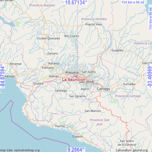
La Asunción GPS coordinates[2]
9° 58' 46.596" North, 84° 10' 22.116" West
| Map corner | latitude | longitude |
|---|---|---|
| Upper-left | 10.67134°, | -84.87594° |
| Center: | 9.97961°, | -84.17281° |
| Lower-right: | 9.2864°, | -83.46969° |
| Map W x H: | 154×154 km | = 95.7×95.7mi |
| max Lat: | 11.07377° ⇑47% North |
| La Asunción: | 9.97961° |
| min Lat: | ⇓53% South 8.53305° |
| min Long | La Asunción | max Long |
| -85.64748° | -84.17281° | -82.62185° |
| W 43.3%⇐ | ⇒56.7% E |
Elevation
Elevation of La Asunción is 956 m = 3136 ft, and this is 221 m = 725 ft above average elevation for this country.
| Max E: |
1844 m = 6050 ft | 46.3% |
| La Asunción | 956 m 3136 ft | |
| Avg. | 735 m = 2411 ft | |
Min E: |
7 m = 23 ft | 53.7% |
See also: Costa Rica elevation on elevation.city.
Geographical zone
La Asunción is located in North Torrid zone (between Equator and Tropic of Cancer). Distance of Equator is 1109.6 km =689.5 mi to South.| Distance of | km | miles | from La Asunción |
|---|---|---|---|
| North Pole | 8897.4 | 5528.6 | to North |
| Arctic Circle | 6291.5 | 3909.4 | to North |
| Tropic Cancer | 1496.3 | 929.8 | to North |
| Equator | 1109.6 | 689.5 | to South |


Nearby cities:
15 places around La Asunción: (largest is in red/bold)
• Alajuela
5.9 km =3.7 mi,  313°
313°
• Colima
10.1 km =6.3 mi,  108°
108°
• Escazú
7.7 km =4.8 mi,  151°
151°
• Heredia
6.7 km =4.2 mi,  67°
67°
• Llorente
2.9 km =1.8 mi,  43°
43°
• Mercedes
5.2 km =3.2 mi,  54°
54°
• Salitral
7.6 km =4.7 mi,  184°
184°
• San Antonio
1.2 km =0.7 mi,  289°
289°
• San Francisco
5 km =3.1 mi, 72°
• San Josecito
9 km =5.6 mi,  62°
62°
• San Pablo
8.5 km =5.3 mi,  77°
77°
• San Rafael
6.9 km =4.3 mi, 145°
• San Rafael
8.8 km =5.5 mi, 64°
• Santa Ana
5.3 km =3.3 mi,  191°
191°
• Santo Domingo
9.6 km =6 mi,  11°
11°
Sources, notices
• [Note1] Compared only with cities in Costa Rica existing in our database
• [Src1] Map data: © OpenStreetMap contributors (CC-BY-SA)
• [Src2] Other city data from geonames.org with taken over terms of usage.
• [Src3] Geographical zone / Annual Mean Temperature by Robert A. Rohde @ Wikipedia
