Alajuela geodata
Alajuela is a seat of a first-order administrative division; located in Costa Rica in America/Costa_Rica (GMT-6) time zone. With population of 47,494 people, there are 3 cities with bigger population in this country. Compared to other cities in Costa Rica, 63.4% of cities are located further ↓South; 60.4% of cities are located further →East and 53% of cities have lower elevation than Alajuela. Note1


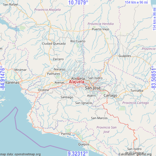
Alajuela GPS coordinates[2]
10° 0' 58.5" North, 84° 12' 41.868" West
| Map corner | latitude | longitude |
|---|---|---|
| Upper-left | 10.7079°, | -84.91476° |
| Center: | 10.01625°, | -84.21163° |
| Lower-right: | 9.32312°, | -83.50851° |
| Map W x H: | 154×154 km | = 95.7×95.7mi |
| max Lat: | 11.07377° ⇑36.6% North |
| Alajuela: | 10.01625° |
| min Lat: | ⇓63.4% South 8.53305° |
| min Long | Alajuela | max Long |
| -85.64748° | -84.21163° | -82.62185° |
| W 39.6%⇐ | ⇒60.4% E |
Elevation
Elevation of Alajuela is 954 m = 3130 ft, and this is 219 m = 719 ft above average elevation for this country.
| Max E: |
1844 m = 6050 ft | 47% |
| Alajuela | 954 m 3130 ft | |
| Avg. | 735 m = 2411 ft | |
Min E: |
7 m = 23 ft | 53% |
See also: Alajuela elevation on elevation.city.
Geographical zone
Alajuela is located in North Torrid zone (between Equator and Tropic of Cancer). Distance of Equator is 1113.7 km =692 mi to South.| Distance of | km | miles | from Alajuela |
|---|---|---|---|
| North Pole | 8893.4 | 5526.1 | to North |
| Arctic Circle | 6287.5 | 3906.9 | to North |
| Tropic Cancer | 1492.2 | 927.2 | to North |
| Equator | 1113.7 | 692 | to South |


Nearby cities:
15 places around Alajuela: (largest is in red/bold)
• Carrillos
7 km =4.3 mi,  281°
281°
• Colón
11.7 km =7.3 mi,  196°
196°
• Heredia
10.5 km =6.5 mi,  98°
98°
• La Asunción
5.9 km =3.7 mi,  133°
133°
• Llorente
6.6 km =4.1 mi,  107°
107°
• Mercedes
8.6 km =5.3 mi, 96°
• Sabanilla
6.4 km =4 mi,  356°
356°
• Salitral
12.2 km =7.6 mi,  162°
162°
• San Antonio
4.8 km =3 mi,  139°
139°
• San Francisco
9.4 km =5.8 mi, 106°
• San Josecito
12.2 km =7.6 mi,  89°
89°
• San Pablo
12.8 km =8 mi, 100°
• San Rafael
12.2 km =7.6 mi, 91°
• Santa Ana
9.8 km =6.1 mi, 161°
• Santo Domingo
8.2 km =5.1 mi,  49°
49°
Sources, notices
• [Note1] Compared only with cities in Costa Rica existing in our database
• [Src1] Map data: © OpenStreetMap contributors (CC-BY-SA)
• [Src2] Other city data from geonames.org with taken over terms of usage.
• [Src3] Geographical zone / Annual Mean Temperature by Robert A. Rohde @ Wikipedia
