Cot geodata
Cot (Cartago) is a populated place; located in Costa Rica in America/Costa_Rica (GMT-6) time zone. With population of 6,784 people, there are 66 cities with bigger population in this country. Compared to other cities in Costa Rica, 70.1% of cities are located further ↑North; 77.6% of cities are located further ←West and 99.3% of cities have lower elevation than Cot. Note1


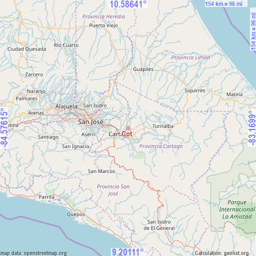
Cot GPS coordinates[2]
9° 53' 40.164" North, 83° 52' 22.872" West
| Map corner | latitude | longitude |
|---|---|---|
| Upper-left | 10.58641°, | -84.57615° |
| Center: | 9.89449°, | -83.87302° |
| Lower-right: | 9.20111°, | -83.1699° |
| Map W x H: | 154×154 km | = 95.7×95.7mi |
| max Lat: | 11.07377° ⇑70.1% North |
| Cot: | 9.89449° |
| min Lat: | ⇓29.9% South 8.53305° |
| min Long | Cot | max Long |
| -85.64748° | -83.87302° | -82.62185° |
| W 77.6%⇐ | ⇒22.4% E |
Elevation
Elevation of Cot is 1811 m = 5942 ft, and this is 1076 m = 3530 ft above average elevation for this country.
| Max E: |
1844 m = 6050 ft | 0.7% |
| Cot | 1811 m 5942 ft | |
| Avg. | 735 m = 2411 ft | |
Min E: |
7 m = 23 ft | 99.3% |
See also: Costa Rica elevation on elevation.city.
Geographical zone
Cot is located in North Torrid zone (between Equator and Tropic of Cancer). Distance of Equator is 1100.2 km =683.6 mi to South.| Distance of | km | miles | from Cot |
|---|---|---|---|
| North Pole | 8906.9 | 5534.5 | to North |
| Arctic Circle | 6301 | 3915.3 | to North |
| Tropic Cancer | 1505.8 | 935.7 | to North |
| Equator | 1100.2 | 683.6 | to South |


Nearby cities:
15 places around Cot: (largest is in red/bold)
• Capellades
10.1 km =6.3 mi,  72°
72°
• Cartago
6.1 km =3.8 mi,  236°
236°
• Concepción
14.6 km =9.1 mi,  287°
287°
• Curridabat
17.7 km =11 mi,  276°
276°
• Granadilla
16.4 km =10.2 mi, 285°
• Ipís
17.4 km =10.8 mi,  297°
297°
• Orosí
11.1 km =6.9 mi,  169°
169°
• Paraíso
6.3 km =3.9 mi, 172°
• Patarrá
17.8 km =11.1 mi,  265°
265°
• Purral
18.6 km =11.6 mi, 292°
• Sabanilla
19.1 km =11.9 mi, 287°
• San Diego
14.2 km =8.8 mi, 272°
• Tobosi
13.7 km =8.5 mi, 242°
• Tres Ríos
12.6 km =7.8 mi, 276°
• Tucurrique
17.1 km =10.6 mi,  105°
105°
Sources, notices
• [Note1] Compared only with cities in Costa Rica existing in our database
• [Src1] Map data: © OpenStreetMap contributors (CC-BY-SA)
• [Src2] Other city data from geonames.org with taken over terms of usage.
• [Src3] Geographical zone / Annual Mean Temperature by Robert A. Rohde @ Wikipedia
