Orosí geodata
Orosí (Cartago) is a populated place; located in Costa Rica in America/Costa_Rica (GMT-6) time zone. With population of 4,350 people, there are 79 cities with bigger population in this country. Compared to other cities in Costa Rica, 85.8% of cities are located further ↑North; 79.1% of cities are located further ←West and 60.4% of cities have lower elevation than Orosí. Note1


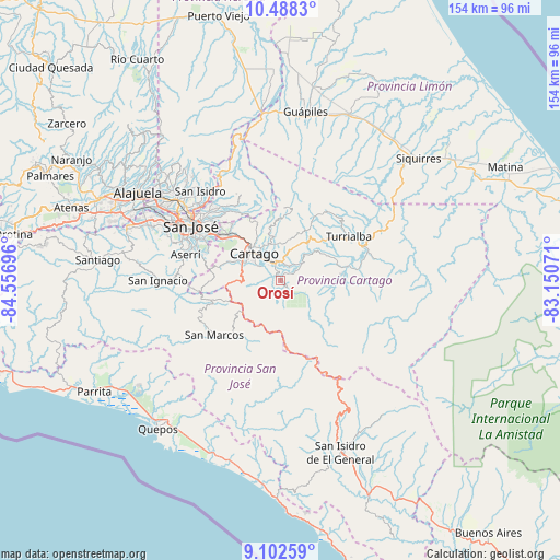
Orosí GPS coordinates[2]
9° 47' 46.212" North, 83° 51' 13.788" West
| Map corner | latitude | longitude |
|---|---|---|
| Upper-left | 10.4883°, | -84.55696° |
| Center: | 9.79617°, | -83.85383° |
| Lower-right: | 9.10259°, | -83.15071° |
| Map W x H: | 154.1×154.1 km | = 95.8×95.8mi |
| max Lat: | 11.07377° ⇑85.8% North |
| Orosí: | 9.79617° |
| min Lat: | ⇓14.2% South 8.53305° |
| min Long | Orosí | max Long |
| -85.64748° | -83.85383° | -82.62185° |
| W 79.1%⇐ | ⇒20.9% E |
Elevation
Elevation of Orosí is 1058 m = 3471 ft, and this is 323 m = 1060 ft above average elevation for this country.
| Max E: |
1844 m = 6050 ft | 39.6% |
| Orosí | 1058 m 3471 ft | |
| Avg. | 735 m = 2411 ft | |
Min E: |
7 m = 23 ft | 60.4% |
See also: Costa Rica elevation on elevation.city.
Geographical zone
Orosí is located in North Torrid zone (between Equator and Tropic of Cancer). Distance of Equator is 1089.2 km =676.8 mi to South.| Distance of | km | miles | from Orosí |
|---|---|---|---|
| North Pole | 8917.8 | 5541.3 | to North |
| Arctic Circle | 6311.9 | 3922 | to North |
| Tropic Cancer | 1516.7 | 942.4 | to North |
| Equator | 1089.2 | 676.8 | to South |


Nearby cities:
15 places around Orosí: (largest is in red/bold)
• Capellades
15.9 km =9.9 mi,  28°
28°
• Cartago
10.5 km =6.5 mi,  316°
316°
• Concepción
22.1 km =13.7 mi,  313°
313°
• Cot
11.1 km =6.9 mi,  349°
349°
• Curridabat
23.6 km =14.7 mi,  303°
303°
• Granadilla
23.6 km =14.7 mi, 310°
• Pacayas
21.3 km =13.2 mi,  273°
273°
• Paraíso
4.9 km =3 mi,  344°
344°
• Patarrá
22 km =13.7 mi, 295°
• Pejibaye
16.6 km =10.3 mi,  84°
84°
• San Diego
19.9 km =12.4 mi, 304°
• Tobosi
15 km =9.3 mi,  288°
288°
• Tres Ríos
19.1 km =11.9 mi, 309°
• Tucurrique
15.7 km =9.8 mi,  66°
66°
• Turrialba
22.2 km =13.8 mi,  57°
57°
Sources, notices
• [Note1] Compared only with cities in Costa Rica existing in our database
• [Src1] Map data: © OpenStreetMap contributors (CC-BY-SA)
• [Src2] Other city data from geonames.org with taken over terms of usage.
• [Src3] Geographical zone / Annual Mean Temperature by Robert A. Rohde @ Wikipedia
