Paraíso geodata
Paraíso (Cartago) is a populated place; located in Costa Rica in America/Costa_Rica (GMT-6) time zone. With population of 39,702 people, there are 5 cities with bigger population in this country. Compared to other cities in Costa Rica, 80.6% of cities are located further ↑North; 78.4% of cities are located further ←West and 91% of cities have lower elevation than Paraíso. Note1


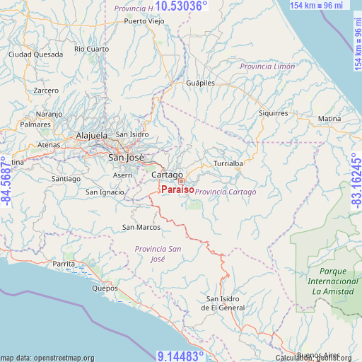
Paraíso GPS coordinates[2]
9° 50' 17.952" North, 83° 51' 56.052" West
| Map corner | latitude | longitude |
|---|---|---|
| Upper-left | 10.53036°, | -84.5687° |
| Center: | 9.83832°, | -83.86557° |
| Lower-right: | 9.14483°, | -83.16245° |
| Map W x H: | 154.1×154.1 km | = 95.8×95.8mi |
| max Lat: | 11.07377° ⇑80.6% North |
| Paraíso: | 9.83832° |
| min Lat: | ⇓19.4% South 8.53305° |
| min Long | Paraíso | max Long |
| -85.64748° | -83.86557° | -82.62185° |
| W 78.4%⇐ | ⇒21.6% E |
Elevation
Elevation of Paraíso is 1332 m = 4370 ft, and this is 597 m = 1959 ft above average elevation for this country.
| Max E: |
1844 m = 6050 ft | 9% |
| Paraíso | 1332 m 4370 ft | |
| Avg. | 735 m = 2411 ft | |
Min E: |
7 m = 23 ft | 91% |
See also: Costa Rica elevation on elevation.city.
Geographical zone
Paraíso is located in North Torrid zone (between Equator and Tropic of Cancer). Distance of Equator is 1093.9 km =679.7 mi to South.| Distance of | km | miles | from Paraíso |
|---|---|---|---|
| North Pole | 8913.1 | 5538.3 | to North |
| Arctic Circle | 6307.3 | 3919.2 | to North |
| Tropic Cancer | 1512 | 939.5 | to North |
| Equator | 1093.9 | 679.7 | to South |


Nearby cities:
15 places around Paraíso: (largest is in red/bold)
• Capellades
12.8 km =8 mi,  43°
43°
• Cartago
6.6 km =4.1 mi,  296°
296°
• Concepción
18.1 km =11.2 mi,  305°
305°
• Cot
6.3 km =3.9 mi,  352°
352°
• Curridabat
20.2 km =12.6 mi,  293°
293°
• Granadilla
19.7 km =12.2 mi, 302°
• Orosí
4.9 km =3 mi,  164°
164°
• Pacayas
20.2 km =12.6 mi,  260°
260°
• Patarrá
19.2 km =11.9 mi,  284°
284°
• Pejibaye
18 km =11.2 mi,  99°
99°
• San Diego
16.5 km =10.3 mi, 294°
• Tobosi
13 km =8.1 mi,  270°
270°
• Tres Ríos
15.4 km =9.6 mi, 299°
• Tucurrique
15.7 km =9.8 mi,  83°
83°
• Turrialba
21.3 km =13.2 mi,  69°
69°
Sources, notices
• [Note1] Compared only with cities in Costa Rica existing in our database
• [Src1] Map data: © OpenStreetMap contributors (CC-BY-SA)
• [Src2] Other city data from geonames.org with taken over terms of usage.
• [Src3] Geographical zone / Annual Mean Temperature by Robert A. Rohde @ Wikipedia
