Remedios geodata
Remedios (Villa Clara) is a seat of a second-order administrative division; located in Cuba in America/Havana (GMT-4) time zone. With population of 34,108 people, there are 72 cities with bigger population in this country. Compared to other cities in Cuba, 59.1% of cities are located further ↓South; 54.1% of cities are located further ←West and 77.9% of cities have higher elevation than Remedios. Note1


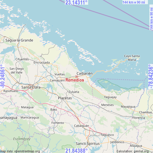
Remedios GPS coordinates[2]
22° 29' 42.072" North, 79° 32' 43.728" West
| Map corner | latitude | longitude |
|---|---|---|
| Upper-left | 23.14311°, | -80.24861° |
| Center: | 22.49502°, | -79.54548° |
| Lower-right: | 21.84388°, | -78.84236° |
| Map W x H: | 144.5×144.5 km | = 89.8×89.8mi |
| max Lat: | 23.15917° ⇑40.9% North |
| Remedios: | 22.49502° |
| min Lat: | ⇓59.1% South 19.90553° |
| min Long | Remedios | max Long |
| -84.28599° | -79.54548° | -74.15181° |
| W 54.1%⇐ | ⇒45.9% E |
Elevation
Elevation of Remedios is 22 m = 72 ft, and this is 46.6 m = 153 ft below average elevation for this country.
| Max E: |
761 m = 2497 ft | 77.9% |
| Avg. | 68.6 m = 225 ft | |
| Remedios | 22 m = 72 ft | |
Min E: |
3 m = 10 ft | 22.1% |
See also: Cuba elevation on elevation.city.
Geographical zone
Remedios is located in North Torrid zone (between Equator and Tropic of Cancer). Distance of this Northern Tropic circle is 104.7 km =65.1 mi to North.| Distance of | km | miles | from Remedios |
|---|---|---|---|
| North Pole | 7505.9 | 4663.9 | to North |
| Arctic Circle | 4900 | 3044.7 | to North |
| Tropic Cancer | 104.7 | 65.1 | to North |
| Equator | 2501.2 | 1554.2 | to South |


Nearby cities:
15 places around Remedios: (largest is in red/bold)
• Cabaiguán
46.6 km =29 mi,  173°
173°
• Caibarién
8.6 km =5.3 mi,  71°
71°
• Calabazar de Sagua
39.6 km =24.6 mi,  294°
294°
• Camajuaní
18.6 km =11.6 mi,  259°
259°
• Camajuaní
21.1 km =13.1 mi,  266°
266°
• Cifuentes
54.5 km =33.9 mi, 288°
• Encrucijada
35.6 km =22.1 mi, 292°
• Esperanza
56.9 km =35.4 mi, 264°
• Fomento
47 km =29.2 mi,  202°
202°
• Guayos
50.3 km =31.3 mi, 170°
• Manicaragua
58.8 km =36.5 mi,  229°
229°
• Placetas
23.2 km =14.4 mi,  208°
208°
• Santa Clara
44.2 km =27.5 mi, 257°
• Yaguajay
36.9 km =22.9 mi,  120°
120°
• Zaza del Medio
58.3 km =36.2 mi,  161°
161°
Sources, notices
• [Note1] Compared only with cities in Cuba existing in our database
• [Src1] Map data: © OpenStreetMap contributors (CC-BY-SA)
• [Src2] Other city data from geonames.org with taken over terms of usage.
• [Src3] Geographical zone / Annual Mean Temperature by Robert A. Rohde @ Wikipedia
