Camajuaní geodata
Camajuaní (Villa Clara) is a populated locality; located in Cuba in America/Havana (GMT-4) time zone. With population of 35,515 people, there are 68 cities with bigger population in this country. Compared to other cities in Cuba, 58.6% of cities are located further ↓South; 51.9% of cities are located further ←West and 73.5% of cities have lower elevation than Camajuaní. Note1


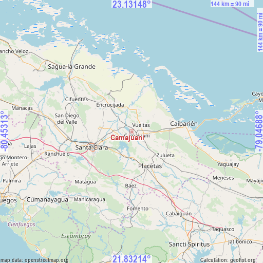
Camajuaní GPS coordinates[2]
22° 28' 59.988" North, 79° 45' 0" West
| Map corner | latitude | longitude |
|---|---|---|
| Upper-left | 23.13148°, | -80.45313° |
| Center: | 22.48333°, | -79.75° |
| Lower-right: | 21.83214°, | -79.04688° |
| Map W x H: | 144.5×144.5 km | = 89.8×89.8mi |
| max Lat: | 23.15917° ⇑41.4% North |
| Camajuaní: | 22.48333° |
| min Lat: | ⇓58.6% South 19.90553° |
| min Long | Camajuaní | max Long |
| -84.28599° | -79.75° | -74.15181° |
| W 51.9%⇐ | ⇒48.1% E |
Elevation
Elevation of Camajuaní is 81 m = 266 ft, and this is 12.4 m = 41 ft above average elevation for this country.
| Max E: |
761 m = 2497 ft | 26.5% |
| Camajuaní | 81 m 266 ft | |
| Avg. | 68.6 m = 225 ft | |
Min E: |
3 m = 10 ft | 73.5% |
See also: Cuba elevation on elevation.city.
Geographical zone
Camajuaní is located in North Torrid zone (between Equator and Tropic of Cancer). Distance of this Northern Tropic circle is 106 km =65.9 mi to North.| Distance of | km | miles | from Camajuaní |
|---|---|---|---|
| North Pole | 7507.1 | 4664.7 | to North |
| Arctic Circle | 4901.3 | 3045.5 | to North |
| Tropic Cancer | 106 | 65.9 | to North |
| Equator | 2499.9 | 1553.4 | to South |


Nearby cities:
15 places around Camajuaní: (largest is in red/bold)
• Cabaiguán
52 km =32.3 mi,  149°
149°
• Caibarién
29.5 km =18.3 mi,  82°
82°
• Calabazar de Sagua
23.4 km =14.5 mi,  320°
320°
• Camajuaní
3.4 km =2.1 mi,  126°
126°
• Cifuentes
35.9 km =22.3 mi,  300°
300°
• Encrucijada
19.1 km =11.9 mi, 321°
• Esperanza
35.9 km =22.3 mi,  263°
263°
• Fomento
42.2 km =26.2 mi,  176°
176°
• Manicaragua
43.9 km =27.3 mi,  212°
212°
• Placetas
21.5 km =13.4 mi, 152°
• Ranchuelo
43 km =26.7 mi,  253°
253°
• Remedios
21.1 km =13.1 mi,  86°
86°
• Sagua la Grande
49.1 km =30.5 mi, 317°
• Santa Clara
23.6 km =14.7 mi, 248°
• Santo Domingo
51.9 km =32.2 mi,  282°
282°
Sources, notices
• [Note1] Compared only with cities in Cuba existing in our database
• [Src1] Map data: © OpenStreetMap contributors (CC-BY-SA)
• [Src2] Other city data from geonames.org with taken over terms of usage.
• [Src3] Geographical zone / Annual Mean Temperature by Robert A. Rohde @ Wikipedia
