Placetas geodata
Placetas (Villa Clara) is a seat of a second-order administrative division; located in Cuba in America/Havana (GMT-4) time zone. With population of 55,408 people, there are 40 cities with bigger population in this country. Compared to other cities in Cuba, 52.5% of cities are located further ↓South; 53.6% of cities are located further ←West and 95.6% of cities have lower elevation than Placetas. Note1


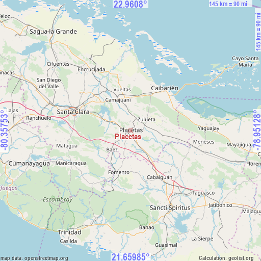
Placetas GPS coordinates[2]
22° 18' 42.624" North, 79° 39' 15.84" West
| Map corner | latitude | longitude |
|---|---|---|
| Upper-left | 22.9608°, | -80.35753° |
| Center: | 22.31184°, | -79.6544° |
| Lower-right: | 21.65985°, | -78.95128° |
| Map W x H: | 144.7×144.7 km | = 89.9×89.9mi |
| max Lat: | 23.15917° ⇑47.5% North |
| Placetas: | 22.31184° |
| min Lat: | ⇓52.5% South 19.90553° |
| min Long | Placetas | max Long |
| -84.28599° | -79.6544° | -74.15181° |
| W 53.6%⇐ | ⇒46.4% E |
Elevation
Elevation of Placetas is 201 m = 659 ft, and this is 132.4 m = 434 ft above average elevation for this country.
| Max E: |
761 m = 2497 ft | 4.4% |
| Placetas | 201 m 659 ft | |
| Avg. | 68.6 m = 225 ft | |
Min E: |
3 m = 10 ft | 95.6% |
See also: Placetas elevation on elevation.city.
Geographical zone
Placetas is located in North Torrid zone (between Equator and Tropic of Cancer). Distance of this Northern Tropic circle is 125.1 km =77.7 mi to North.| Distance of | km | miles | from Placetas |
|---|---|---|---|
| North Pole | 7526.2 | 4676.6 | to North |
| Arctic Circle | 4920.3 | 3057.3 | to North |
| Tropic Cancer | 125.1 | 77.7 | to North |
| Equator | 2480.8 | 1541.5 | to South |


Nearby cities:
15 places around Placetas: (largest is in red/bold)
• Cabaiguán
30.6 km =19 mi,  148°
148°
• Caibarién
30.2 km =18.8 mi,  39°
39°
• Calabazar de Sagua
44.6 km =27.7 mi,  326°
326°
• Camajuaní
18.4 km =11.4 mi,  337°
337°
• Camajuaní
21.5 km =13.4 mi, 332°
• Encrucijada
40.4 km =25.1 mi, 327°
• Esperanza
47.9 km =29.8 mi,  288°
288°
• Fomento
24 km =14.9 mi,  196°
196°
• Guayos
35.3 km =21.9 mi, 145°
• Manicaragua
37.9 km =23.5 mi,  241°
241°
• Remedios
23.2 km =14.4 mi,  28°
28°
• Sancti Spíritus
47.8 km =29.7 mi, 152°
• Santa Clara
33.6 km =20.9 mi, 288°
• Yaguajay
43.1 km =26.8 mi,  87°
87°
• Zaza del Medio
45.8 km =28.5 mi,  139°
139°
Sources, notices
• [Note1] Compared only with cities in Cuba existing in our database
• [Src1] Map data: © OpenStreetMap contributors (CC-BY-SA)
• [Src2] Other city data from geonames.org with taken over terms of usage.
• [Src3] Geographical zone / Annual Mean Temperature by Robert A. Rohde @ Wikipedia
