Pinar del Río geodata
Pinar del Río is a seat of a first-order administrative division; located in Cuba in America/Havana (GMT-4) time zone. With population of 186,990 people, there are 11 cities with bigger population in this country. Compared to other cities in Cuba, 56.9% of cities are located further ↓South; 96.1% of cities are located further →East and 52.5% of cities have lower elevation than Pinar del Río. Note1


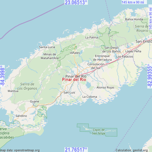
Pinar del Río GPS coordinates[2]
22° 25' 0.012" North, 83° 41' 48.012" West
| Map corner | latitude | longitude |
|---|---|---|
| Upper-left | 23.06513°, | -84.3998° |
| Center: | 22.41667°, | -83.69667° |
| Lower-right: | 21.76517°, | -82.99355° |
| Map W x H: | 144.5×144.5 km | = 89.8×89.8mi |
| max Lat: | 23.15917° ⇑43.1% North |
| Pinar del Río: | 22.41667° |
| min Lat: | ⇓56.9% South 19.90553° |
| min Long | Pinar del Río | max Long |
| -84.28599° | -83.69667° | -74.15181° |
| W 3.9%⇐ | ⇒96.1% E |
Elevation
Elevation of Pinar del Río is 55 m = 180 ft, and this is 13.6 m = 45 ft below average elevation for this country.
| Max E: |
761 m = 2497 ft | 47.5% |
| Avg. | 68.6 m = 225 ft | |
| Pinar del Río | 55 m = 180 ft | |
Min E: |
3 m = 10 ft | 52.5% |
See also: Pinar del Río elevation on elevation.city.
Geographical zone
Pinar del Río is located in North Torrid zone (between Equator and Tropic of Cancer). Distance of this Northern Tropic circle is 113.4 km =70.5 mi to North.| Distance of | km | miles | from Pinar del Río |
|---|---|---|---|
| North Pole | 7514.6 | 4669.4 | to North |
| Arctic Circle | 4908.7 | 3050.1 | to North |
| Tropic Cancer | 113.4 | 70.5 | to North |
| Equator | 2492.5 | 1548.8 | to South |


Nearby cities:
15 places around Pinar del Río: (largest is in red/bold)
• Bahía Honda
77.2 km =48 mi,  45°
45°
• Candelaria
83.9 km =52.1 mi,  64°
64°
• Consolación del Sur
21.1 km =13.1 mi, 62°
• Guane
46.5 km =28.9 mi,  239°
239°
• La Palma
39.8 km =24.7 mi,  21°
21°
• Los Palacios
50 km =31.1 mi,  67°
67°
• Mantua
62.2 km =38.6 mi,  256°
256°
• Minas de Matahambre
31.8 km =19.8 mi,  306°
306°
• Puerto Esperanza
39.5 km =24.5 mi,  354°
354°
• San Cristobal
73.7 km =45.8 mi, 63°
• San Diego de Los Baños
42.2 km =26.2 mi, 52°
• San Juan y Martínez
21.2 km =13.2 mi,  224°
224°
• San Luis
16.6 km =10.3 mi,  202°
202°
• Soroa
81.8 km =50.8 mi, 58°
• Viñales
22.5 km =14 mi,  357°
357°
Sources, notices
• [Note1] Compared only with cities in Cuba existing in our database
• [Src1] Map data: © OpenStreetMap contributors (CC-BY-SA)
• [Src2] Other city data from geonames.org with taken over terms of usage.
• [Src3] Geographical zone / Annual Mean Temperature by Robert A. Rohde @ Wikipedia
