Guane geodata
Guane (Pinar del Río) is a populated place; located in Cuba in America/Havana (GMT-4) time zone. With population of 16,548 people, there are 124 cities with bigger population in this country. Compared to other cities in Cuba, 50.8% of cities are located further ↑North; 99.4% of cities are located further →East and 76.2% of cities have higher elevation than Guane. Note1


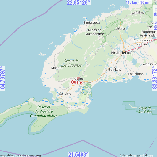
Guane GPS coordinates[2]
22° 12' 6.444" North, 84° 5' 5.424" West
| Map corner | latitude | longitude |
|---|---|---|
| Upper-left | 22.85126°, | -84.78797° |
| Center: | 22.20179°, | -84.08484° |
| Lower-right: | 21.5493°, | -83.38172° |
| Map W x H: | 144.8×144.8 km | = 90×90mi |
| max Lat: | 23.15917° ⇑50.8% North |
| Guane: | 22.20179° |
| min Lat: | ⇓49.2% South 19.90553° |
| min Long | Guane | max Long |
| -84.28599° | -84.08484° | -74.15181° |
| W 0.6%⇐ | ⇒99.4% E |
Elevation
Elevation of Guane is 23 m = 75 ft, and this is 45.6 m = 150 ft below average elevation for this country.
| Max E: |
761 m = 2497 ft | 76.2% |
| Avg. | 68.6 m = 225 ft | |
| Guane | 23 m = 75 ft | |
Min E: |
3 m = 10 ft | 23.8% |
See also: Cuba elevation on elevation.city.
Geographical zone
Guane is located in North Torrid zone (between Equator and Tropic of Cancer). Distance of this Northern Tropic circle is 137.3 km =85.3 mi to North.| Distance of | km | miles | from Guane |
|---|---|---|---|
| North Pole | 7538.5 | 4684.2 | to North |
| Arctic Circle | 4932.6 | 3065 | to North |
| Tropic Cancer | 137.3 | 85.3 | to North |
| Equator | 2468.6 | 1533.9 | to South |


Nearby cities:
15 places around Guane: (largest is in red/bold)
• Bahía Honda
122.9 km =76.4 mi,  50°
50°
• Candelaria
130.3 km =81 mi,  62°
62°
• Consolación del Sur
67.6 km =42 mi, 60°
• La Palma
81.8 km =50.8 mi,  41°
41°
• Los Palacios
96.3 km =59.8 mi, 63°
• Mantua
22.9 km =14.2 mi,  295°
295°
• Minas de Matahambre
45.2 km =28.1 mi,  18°
18°
• Pinar del Río
46.5 km =28.9 mi, 59°
• Puerto Esperanza
72.9 km =45.3 mi,  29°
29°
• San Cristobal
120.2 km =74.7 mi, 61°
• San Diego de Los Baños
88.6 km =55.1 mi, 56°
• San Juan y Martínez
26.6 km =16.5 mi,  71°
71°
• San Luis
34.6 km =21.5 mi,  75°
75°
• Soroa
128.3 km =79.7 mi, 58°
• Viñales
60.5 km =37.6 mi, 39°
Sources, notices
• [Note1] Compared only with cities in Cuba existing in our database
• [Src1] Map data: © OpenStreetMap contributors (CC-BY-SA)
• [Src2] Other city data from geonames.org with taken over terms of usage.
• [Src3] Geographical zone / Annual Mean Temperature by Robert A. Rohde @ Wikipedia
