Bahía Honda geodata
Bahía Honda (Artemisa) is a seat of a second-order administrative division; located in Cuba in America/Havana (GMT-4) time zone. With population of 19,834 people, there are 108 cities with bigger population in this country. Compared to other cities in Cuba, 82.9% of cities are located further ↓South; 93.4% of cities are located further →East and 80.1% of cities have higher elevation than Bahía Honda. Note1


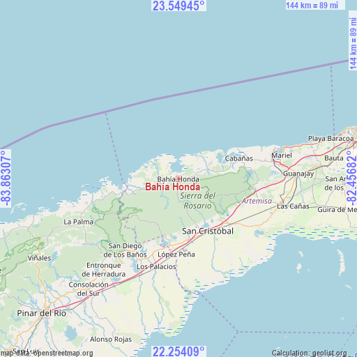
Bahía Honda GPS coordinates[2]
22° 54' 11.952" North, 83° 9' 35.784" West
| Map corner | latitude | longitude |
|---|---|---|
| Upper-left | 23.54945°, | -83.86307° |
| Center: | 22.90332°, | -83.15994° |
| Lower-right: | 22.25409°, | -82.45682° |
| Map W x H: | 144×144 km | = 89.5×89.5mi |
| max Lat: | 23.15917° ⇑17.1% North |
| Bahía Honda: | 22.90332° |
| min Lat: | ⇓82.9% South 19.90553° |
| min Long | Bahía Honda | max Long |
| -84.28599° | -83.15994° | -74.15181° |
| W 6.6%⇐ | ⇒93.4% E |
Elevation
Elevation of Bahía Honda is 21 m = 69 ft, and this is 47.6 m = 156 ft below average elevation for this country.
| Max E: |
761 m = 2497 ft | 80.1% |
| Avg. | 68.6 m = 225 ft | |
| Bahía Honda | 21 m = 69 ft | |
Min E: |
3 m = 10 ft | 19.9% |
See also: Cuba elevation on elevation.city.
Geographical zone
Bahía Honda is located in North Torrid zone (between Equator and Tropic of Cancer). Distance of this Northern Tropic circle is 59.3 km =36.8 mi to North.| Distance of | km | miles | from Bahía Honda |
|---|---|---|---|
| North Pole | 7460.5 | 4635.7 | to North |
| Arctic Circle | 4854.6 | 3016.5 | to North |
| Tropic Cancer | 59.3 | 36.8 | to North |
| Equator | 2546.6 | 1582.4 | to South |


Nearby cities:
15 places around Bahía Honda: (largest is in red/bold)
• Alquízar
60 km =37.3 mi,  100°
100°
• Artemisa
42.1 km =26.2 mi, 103°
• Bauta
63.4 km =39.4 mi,  82°
82°
• Cabañas
25.8 km =16 mi,  70°
70°
• Caimito
58.2 km =36.2 mi, 84°
• Candelaria
27.4 km =17 mi,  131°
131°
• Consolación del Sur
57.4 km =35.7 mi,  219°
219°
• Guanajay
48.5 km =30.1 mi,  86°
86°
• La Palma
43.9 km =27.3 mi,  247°
247°
• Los Palacios
36.1 km =22.4 mi,  194°
194°
• Mariel
42.7 km =26.5 mi, 77°
• Puerto Esperanza
60.4 km =37.5 mi,  255°
255°
• San Cristobal
23.3 km =14.5 mi,  152°
152°
• San Diego de Los Baños
35.7 km =22.2 mi, 217°
• Soroa
18.6 km =11.6 mi, 128°
Sources, notices
• [Note1] Compared only with cities in Cuba existing in our database
• [Src1] Map data: © OpenStreetMap contributors (CC-BY-SA)
• [Src2] Other city data from geonames.org with taken over terms of usage.
• [Src3] Geographical zone / Annual Mean Temperature by Robert A. Rohde @ Wikipedia
