Corralillo geodata
Corralillo (Villa Clara) is a seat of a second-order administrative division; located in Cuba in America/Havana (GMT-4) time zone. With population of 51,881 people, there are 46 cities with bigger population in this country. Compared to other cities in Cuba, 89.5% of cities are located further ↓South; 60.8% of cities are located further →East and 69.6% of cities have higher elevation than Corralillo. Note1


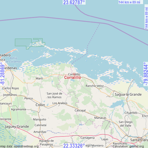
Corralillo GPS coordinates[2]
22° 58' 55.632" North, 80° 35' 8.016" West
| Map corner | latitude | longitude |
|---|---|---|
| Upper-left | 23.62787°, | -81.28869° |
| Center: | 22.98212°, | -80.58556° |
| Lower-right: | 22.33326°, | -79.88244° |
| Map W x H: | 143.9×143.9 km | = 89.4×89.4mi |
| max Lat: | 23.15917° ⇑10.5% North |
| Corralillo: | 22.98212° |
| min Lat: | ⇓89.5% South 19.90553° |
| min Long | Corralillo | max Long |
| -84.28599° | -80.58556° | -74.15181° |
| W 39.2%⇐ | ⇒60.8% E |
Elevation
Elevation of Corralillo is 27 m = 89 ft, and this is 41.6 m = 136 ft below average elevation for this country.
| Max E: |
761 m = 2497 ft | 69.6% |
| Avg. | 68.6 m = 225 ft | |
| Corralillo | 27 m = 89 ft | |
Min E: |
3 m = 10 ft | 30.4% |
See also: Corralillo elevation on elevation.city.
Geographical zone
Corralillo is located in North Torrid zone (between Equator and Tropic of Cancer). Distance of this Northern Tropic circle is 50.5 km =31.4 mi to North.| Distance of | km | miles | from Corralillo |
|---|---|---|---|
| North Pole | 7451.7 | 4630.3 | to North |
| Arctic Circle | 4845.8 | 3011 | to North |
| Tropic Cancer | 50.5 | 31.4 | to North |
| Equator | 2555.4 | 1587.9 | to South |


Nearby cities:
15 places around Corralillo: (largest is in red/bold)
• Calimete
60 km =37.3 mi,  213°
213°
• Cifuentes
66.3 km =41.2 mi,  123°
123°
• Colón
43.8 km =27.2 mi,  228°
228°
• Cárdenas
63.8 km =39.6 mi,  275°
275°
• Isabela de Sagua
58.9 km =36.6 mi,  94°
94°
• Jovellanos
65.1 km =40.5 mi,  252°
252°
• Lajas
69.9 km =43.4 mi,  154°
154°
• Los Arabos
31.3 km =19.4 mi, 206°
• Manguito
55.4 km =34.4 mi,  217°
217°
• Martí
34.4 km =21.4 mi,  263°
263°
• Perico
50.2 km =31.2 mi,  241°
241°
• Quemado de Güines
40.4 km =25.1 mi, 122°
• Rancho Veloz
22.9 km =14.2 mi, 119°
• Sagua la Grande
55.8 km =34.7 mi,  110°
110°
• Santo Domingo
56.3 km =35 mi,  141°
141°
Sources, notices
• [Note1] Compared only with cities in Cuba existing in our database
• [Src1] Map data: © OpenStreetMap contributors (CC-BY-SA)
• [Src2] Other city data from geonames.org with taken over terms of usage.
• [Src3] Geographical zone / Annual Mean Temperature by Robert A. Rohde @ Wikipedia
