Sagua la Grande geodata
Sagua la Grande (Villa Clara) is a seat of a second-order administrative division; located in Cuba in America/Havana (GMT-4) time zone. With population of 62,073 people, there are 37 cities with bigger population in this country. Compared to other cities in Cuba, 77.9% of cities are located further ↓South; 53.6% of cities are located further →East and 89% of cities have higher elevation than Sagua la Grande. Note1


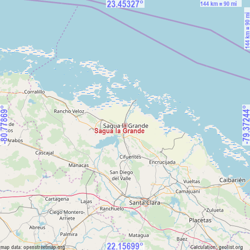
Sagua la Grande GPS coordinates[2]
22° 48' 24.012" North, 80° 4' 32.016" West
| Map corner | latitude | longitude |
|---|---|---|
| Upper-left | 23.45327°, | -80.77869° |
| Center: | 22.80667°, | -80.07556° |
| Lower-right: | 22.15699°, | -79.37244° |
| Map W x H: | 144.1×144.1 km | = 89.5×89.5mi |
| max Lat: | 23.15917° ⇑22.1% North |
| Sagua la Grande: | 22.80667° |
| min Lat: | ⇓77.9% South 19.90553° |
| min Long | Sagua la Grande | max Long |
| -84.28599° | -80.07556° | -74.15181° |
| W 46.4%⇐ | ⇒53.6% E |
Elevation
Elevation of Sagua la Grande is 13 m = 43 ft, and this is 55.6 m = 182 ft below average elevation for this country.
| Max E: |
761 m = 2497 ft | 89% |
| Avg. | 68.6 m = 225 ft | |
| Sagua la Grande | 13 m = 43 ft | |
Min E: |
3 m = 10 ft | 11% |
See also: Sagua la Grande elevation on elevation.city.
Geographical zone
Sagua la Grande is located in North Torrid zone (between Equator and Tropic of Cancer). Distance of this Northern Tropic circle is 70.1 km =43.6 mi to North.| Distance of | km | miles | from Sagua la Grande |
|---|---|---|---|
| North Pole | 7471.2 | 4642.4 | to North |
| Arctic Circle | 4865.3 | 3023.2 | to North |
| Tropic Cancer | 70.1 | 43.6 | to North |
| Equator | 2535.9 | 1575.7 | to South |


Nearby cities:
15 places around Sagua la Grande: (largest is in red/bold)
• Calabazar de Sagua
25.8 km =16 mi,  134°
134°
• Camajuaní
49.1 km =30.5 mi,  137°
137°
• Camajuaní
52.5 km =32.6 mi, 136°
• Cifuentes
17.7 km =11 mi,  171°
171°
• Corralillo
55.8 km =34.7 mi,  290°
290°
• Cruces
55.4 km =34.4 mi,  201°
201°
• Encrucijada
30 km =18.6 mi, 134°
• Esperanza
40.1 km =24.9 mi,  183°
183°
• Isabela de Sagua
16.1 km =10 mi,  23°
23°
• Lajas
49 km =30.4 mi,  207°
207°
• Quemado de Güines
18.2 km =11.3 mi,  263°
263°
• Rancho Veloz
33.3 km =20.7 mi,  284°
284°
• Ranchuelo
48.9 km =30.4 mi,  189°
189°
• Santa Clara
45.9 km =28.5 mi, 165°
• Santo Domingo
29.9 km =18.6 mi,  215°
215°
Sources, notices
• [Note1] Compared only with cities in Cuba existing in our database
• [Src1] Map data: © OpenStreetMap contributors (CC-BY-SA)
• [Src2] Other city data from geonames.org with taken over terms of usage.
• [Src3] Geographical zone / Annual Mean Temperature by Robert A. Rohde @ Wikipedia
