Quemado de Güines geodata
Quemado de Güines (Villa Clara) is a seat of a second-order administrative division; located in Cuba in America/Havana (GMT-4) time zone. With population of 12,736 people, there are 134 cities with bigger population in this country. Compared to other cities in Cuba, 74.6% of cities are located further ↓South; 56.4% of cities are located further →East and 75.1% of cities have lower elevation than Quemado de Güines. Note1


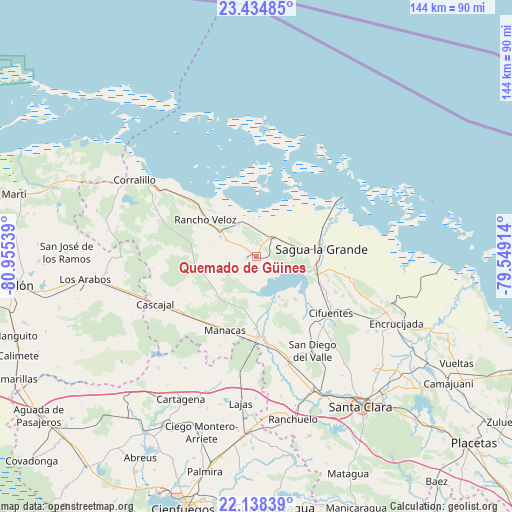
Quemado de Güines GPS coordinates[2]
22° 47' 17.376" North, 80° 15' 8.136" West
| Map corner | latitude | longitude |
|---|---|---|
| Upper-left | 23.43485°, | -80.95539° |
| Center: | 22.78816°, | -80.25226° |
| Lower-right: | 22.13839°, | -79.54914° |
| Map W x H: | 144.2×144.2 km | = 89.6×89.6mi |
| max Lat: | 23.15917° ⇑25.4% North |
| Quemado de Güines: | 22.78816° |
| min Lat: | ⇓74.6% South 19.90553° |
| min Long | Quemado de Güi | max Long |
| -84.28599° | -80.25226° | -74.15181° |
| W 43.6%⇐ | ⇒56.4% E |
Elevation
Elevation of Quemado de Güines is 85 m = 279 ft, and this is 16.4 m = 54 ft above average elevation for this country.
| Max E: |
761 m = 2497 ft | 24.9% |
| Quemado de Güines | 85 m 279 ft | |
| Avg. | 68.6 m = 225 ft | |
Min E: |
3 m = 10 ft | 75.1% |
See also: Cuba elevation on elevation.city.
Geographical zone
Quemado de Güines is located in North Torrid zone (between Equator and Tropic of Cancer). Distance of this Northern Tropic circle is 72.1 km =44.8 mi to North.| Distance of | km | miles | from Quemado de Güines |
|---|---|---|---|
| North Pole | 7473.3 | 4643.7 | to North |
| Arctic Circle | 4867.4 | 3024.5 | to North |
| Tropic Cancer | 72.1 | 44.8 | to North |
| Equator | 2533.8 | 1574.4 | to South |


Nearby cities:
15 places around Quemado de Güines: (largest is in red/bold)
• Calabazar de Sagua
39.9 km =24.8 mi,  113°
113°
• Cifuentes
25.9 km =16.1 mi,  126°
126°
• Corralillo
40.4 km =25.1 mi,  302°
302°
• Cruces
49.6 km =30.8 mi,  182°
182°
• Encrucijada
43.9 km =27.3 mi,  115°
115°
• Esperanza
41.2 km =25.6 mi,  157°
157°
• Isabela de Sagua
29.8 km =18.5 mi,  55°
55°
• Lajas
41.7 km =25.9 mi,  185°
185°
• Los Arabos
48.5 km =30.1 mi,  262°
262°
• Rancho Veloz
17.5 km =10.9 mi,  305°
305°
• Ranchuelo
47.4 km =29.5 mi,  167°
167°
• Rodas
58.6 km =36.4 mi,  212°
212°
• Sagua la Grande
18.2 km =11.3 mi,  83°
83°
• Santa Clara
51.7 km =32.1 mi,  145°
145°
• Santo Domingo
22.4 km =13.9 mi, 177°
Sources, notices
• [Note1] Compared only with cities in Cuba existing in our database
• [Src1] Map data: © OpenStreetMap contributors (CC-BY-SA)
• [Src2] Other city data from geonames.org with taken over terms of usage.
• [Src3] Geographical zone / Annual Mean Temperature by Robert A. Rohde @ Wikipedia
