San Germán geodata
San Germán (Holguín) is a seat of a second-order administrative division; located in Cuba in America/Havana (GMT-4) time zone. With population of 43,892 people, there are 55 cities with bigger population in this country. Compared to other cities in Cuba, 84.5% of cities are located further ↑North; 87.3% of cities are located further ←West and 79.6% of cities have lower elevation than San Germán. Note1


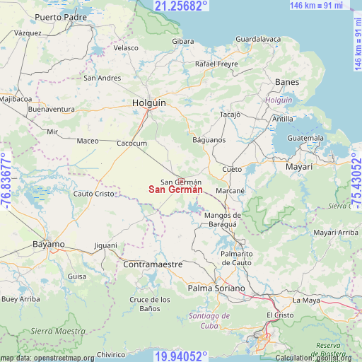
San Germán GPS coordinates[2]
20° 36' 0.324" North, 76° 8' 1.104" West
| Map corner | latitude | longitude |
|---|---|---|
| Upper-left | 21.25682°, | -76.83677° |
| Center: | 20.60009°, | -76.13364° |
| Lower-right: | 19.94052°, | -75.43052° |
| Map W x H: | 146.4×146.4 km | = 91×91mi |
| max Lat: | 23.15917° ⇑84.5% North |
| San Germán: | 20.60009° |
| min Lat: | ⇓15.5% South 19.90553° |
| min Long | San Germán | max Long |
| -84.28599° | -76.13364° | -74.15181° |
| W 87.3%⇐ | ⇒12.7% E |
Elevation
Elevation of San Germán is 98 m = 322 ft, and this is 29.4 m = 96 ft above average elevation for this country.
| Max E: |
761 m = 2497 ft | 20.4% |
| San Germán | 98 m 322 ft | |
| Avg. | 68.6 m = 225 ft | |
Min E: |
3 m = 10 ft | 79.6% |
See also: San Germán elevation on elevation.city.
Geographical zone
San Germán is located in North Torrid zone (between Equator and Tropic of Cancer). Distance of this Northern Tropic circle is 315.4 km =196 mi to North.| Distance of | km | miles | from San Germán |
|---|---|---|---|
| North Pole | 7716.5 | 4794.8 | to North |
| Arctic Circle | 5110.7 | 3175.6 | to North |
| Tropic Cancer | 315.4 | 196 | to North |
| Equator | 2290.5 | 1423.3 | to South |


Nearby cities:
15 places around San Germán: (largest is in red/bold)
• Antilla
48.7 km =30.3 mi,  58°
58°
• Báguanos
20.2 km =12.6 mi,  33°
33°
• Cacocum
25.2 km =15.7 mi,  307°
307°
• Cauto Cristo
35.6 km =22.1 mi,  262°
262°
• Contramaestre
35.5 km =22.1 mi,  199°
199°
• Cueto
21.9 km =13.6 mi,  75°
75°
• Gibara
56.7 km =35.2 mi,  0°
0°
• Guisa
57.1 km =35.5 mi,  227°
227°
• Holguín
34.6 km =21.5 mi,  337°
337°
• Jiguaní
40 km =24.9 mi, 229°
• Jobabo
44.5 km =27.7 mi, 337°
• Mayarí
47.6 km =29.6 mi, 82°
• Palma Soriano
45.6 km =28.3 mi,  161°
161°
• San Luis
54.5 km =33.9 mi,  147°
147°
• Santa Lucía
49.9 km =31 mi,  16°
16°
Sources, notices
• [Note1] Compared only with cities in Cuba existing in our database
• [Src1] Map data: © OpenStreetMap contributors (CC-BY-SA)
• [Src2] Other city data from geonames.org with taken over terms of usage.
• [Src3] Geographical zone / Annual Mean Temperature by Robert A. Rohde @ Wikipedia
