Palma Soriano geodata
Palma Soriano (Santiago de Cuba) is a seat of a second-order administrative division; located in Cuba in America/Havana (GMT-4) time zone. With population of 102,826 people, there are 22 cities with bigger population in this country. Compared to other cities in Cuba, 93.4% of cities are located further ↑North; 89.5% of cities are located further ←West and 95% of cities have lower elevation than Palma Soriano. Note1


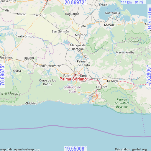
Palma Soriano GPS coordinates[2]
20° 12' 40.68" North, 75° 59' 37.032" West
| Map corner | latitude | longitude |
|---|---|---|
| Upper-left | 20.86972°, | -76.69675° |
| Center: | 20.2113°, | -75.99362° |
| Lower-right: | 19.55008°, | -75.2905° |
| Map W x H: | 146.7×146.7 km | = 91.2×91.2mi |
| max Lat: | 23.15917° ⇑93.4% North |
| Palma Soriano: | 20.2113° |
| min Lat: | ⇓6.6% South 19.90553° |
| min Long | Palma Soriano | max Long |
| -84.28599° | -75.99362° | -74.15181° |
| W 89.5%⇐ | ⇒10.5% E |
Elevation
Elevation of Palma Soriano is 152 m = 499 ft, and this is 83.4 m = 274 ft above average elevation for this country.
| Max E: |
761 m = 2497 ft | 5% |
| Palma Soriano | 152 m 499 ft | |
| Avg. | 68.6 m = 225 ft | |
Min E: |
3 m = 10 ft | 95% |
See also: Palma Soriano elevation on elevation.city.
Geographical zone
Palma Soriano is located in North Torrid zone (between Equator and Tropic of Cancer). Distance of this Northern Tropic circle is 358.6 km =222.8 mi to North.| Distance of | km | miles | from Palma Soriano |
|---|---|---|---|
| North Pole | 7759.8 | 4821.7 | to North |
| Arctic Circle | 5153.9 | 3202.5 | to North |
| Tropic Cancer | 358.6 | 222.8 | to North |
| Equator | 2247.3 | 1396.4 | to South |


Nearby cities:
15 places around Palma Soriano: (largest is in red/bold)
• Antilla
74 km =46 mi,  21°
21°
• Bayamo
70.2 km =43.6 mi,  284°
284°
• Báguanos
60.1 km =37.3 mi,  356°
356°
• Cacocum
68 km =42.3 mi,  329°
329°
• Cauto Cristo
63 km =39.1 mi,  307°
307°
• Contramaestre
28 km =17.4 mi,  290°
290°
• Cueto
49.1 km =30.5 mi,  7°
7°
• El Cobre
18.8 km =11.7 mi,  164°
164°
• Guisa
57.1 km =35.5 mi,  274°
274°
• Jiguaní
48.5 km =30.1 mi, 291°
• Mayarí
59.1 km =36.7 mi,  33°
33°
• San Germán
45.6 km =28.3 mi,  341°
341°
• San Luis
15.2 km =9.4 mi,  99°
99°
• Santiago de Cuba
27.4 km =17 mi,  140°
140°
• Segundo Frente
56.5 km =35.1 mi,  66°
66°
Sources, notices
• [Note1] Compared only with cities in Cuba existing in our database
• [Src1] Map data: © OpenStreetMap contributors (CC-BY-SA)
• [Src2] Other city data from geonames.org with taken over terms of usage.
• [Src3] Geographical zone / Annual Mean Temperature by Robert A. Rohde @ Wikipedia
