Perivólia geodata
Perivólia (Larnaka) is a populated place; located in Cyprus in Asia/Nicosia (GMT+3) time zone. With population of 1,876 people, there are 53 cities with bigger population in this country. Compared to other cities in Cyprus, 70.1% of cities are located further ↑North; 78.6% of cities are located further ←West and 97.4% of cities have higher elevation than Perivólia. Note1


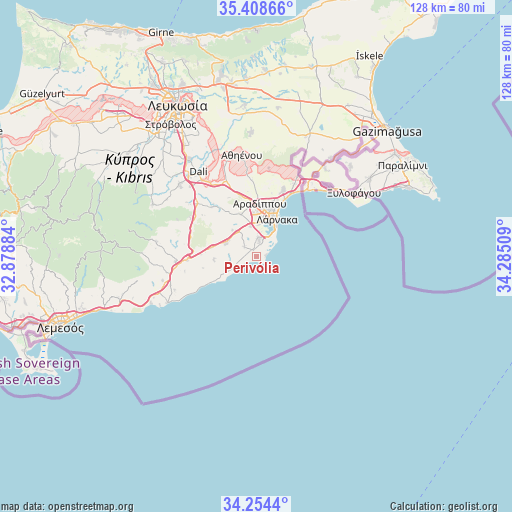
Perivólia GPS coordinates[2]
34° 50' 0.78" North, 33° 34' 55.056" East
| Map corner | latitude | longitude |
|---|---|---|
| Upper-left | 35.40866°, | 32.87884° |
| Center: | 34.83355°, | 33.58196° |
| Lower-right: | 34.2544°, | 34.28509° |
| Map W x H: | 128.3×128.3 km | = 79.7×79.7mi |
| max Lat: | 35.59719° ⇑70.1% North |
| Perivólia: | 34.83355° |
| min Lat: | ⇓29.9% South 34.66865° |
| min Long | Perivólia | max Long |
| 32.38166° | 33.58196° | 34.37916° |
| W 78.6%⇐ | ⇒21.4% E |
Elevation
Elevation of Perivólia is 11 m = 36 ft, and this is 197 m = 646 ft below average elevation for this country.
| Max E: |
1134 m = 3720 ft | 97.4% |
| Avg. | 208 m = 682 ft | |
| Perivólia | 11 m = 36 ft | |
Min E: |
4 m = 13 ft | 2.6% |
See also: Cyprus elevation on elevation.city.
Geographical zone
Perivólia is located in North temperate zone (between Tropic of Cancer and the Arctic Circle). Distance of this Northern Tropic circle is 1267.2 km =787.4 mi to South.| Distance of | km | miles | from Perivólia |
|---|---|---|---|
| North Pole | 6133.9 | 3811.4 | to North |
| Arctic Circle | 3528 | 2192.2 | to North |
| Tropic Cancer | 1267.2 | 787.4 | to South |
| Equator | 3873.1 | 2406.6 | to South |


Nearby cities:
15 places around Perivólia: (largest is in red/bold)
• Alethrikó
8.5 km =5.3 mi,  290°
290°
• Anafotída
10.9 km =6.8 mi,  264°
264°
• Aradíppou
13.1 km =8.1 mi,  3°
3°
• Dhromolaxia
4.7 km =2.9 mi,  5°
5°
• Kofínou
17.4 km =10.8 mi,  266°
266°
• Kíti
1.7 km =1.1 mi,  332°
332°
• Kórnos
19.6 km =12.2 mi,  300°
300°
• Larnaca
10.6 km =6.6 mi,  20°
20°
• Livádia
13.7 km =8.5 mi, 17°
• Mazotós
9.1 km =5.7 mi,  248°
248°
• Meneou
3.3 km =2.1 mi, 21°
• Mosfilotí
19.5 km =12.1 mi,  312°
312°
• Psevdás
16.6 km =10.3 mi,  319°
319°
• Tersefánou
3.9 km =2.4 mi, 305°
• Voróklini
18.2 km =11.3 mi, 21°
Sources, notices
• [Note1] Compared only with cities in Cyprus existing in our database
• [Src1] Map data: © OpenStreetMap contributors (CC-BY-SA)
• [Src2] Other city data from geonames.org with taken over terms of usage.
• [Src3] Geographical zone / Annual Mean Temperature by Robert A. Rohde @ Wikipedia
