Dhromolaxia geodata
Dhromolaxia (Larnaka) is a populated place; located in Cyprus in Asia/Nicosia (GMT+3) time zone. With population of 5,240 people, there are 19 cities with bigger population in this country. Compared to other cities in Cyprus, 62.4% of cities are located further ↑North; 79.5% of cities are located further ←West and 86.3% of cities have higher elevation than Dhromolaxia. Note1


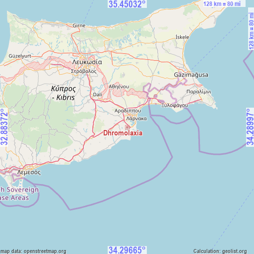
Dhromolaxia GPS coordinates[2]
34° 52' 31.836" North, 33° 35' 12.624" East
| Map corner | latitude | longitude |
|---|---|---|
| Upper-left | 35.45032°, | 32.88372° |
| Center: | 34.87551°, | 33.58684° |
| Lower-right: | 34.29665°, | 34.28997° |
| Map W x H: | 128.3×128.3 km | = 79.7×79.7mi |
| max Lat: | 35.59719° ⇑62.4% North |
| Dhromolaxia: | 34.87551° |
| min Lat: | ⇓37.6% South 34.66865° |
| min Long | Dhromolaxia | max Long |
| 32.38166° | 33.58684° | 34.37916° |
| W 79.5%⇐ | ⇒20.5% E |
Elevation
Elevation of Dhromolaxia is 31 m = 102 ft, and this is 177 m = 581 ft below average elevation for this country.
| Max E: |
1134 m = 3720 ft | 86.3% |
| Avg. | 208 m = 682 ft | |
| Dhromolaxia | 31 m = 102 ft | |
Min E: |
4 m = 13 ft | 13.7% |
See also: Cyprus elevation on elevation.city.
Geographical zone
Dhromolaxia is located in North temperate zone (between Tropic of Cancer and the Arctic Circle). Distance of this Northern Tropic circle is 1271.9 km =790.3 mi to South.| Distance of | km | miles | from Dhromolaxia |
|---|---|---|---|
| North Pole | 6129.3 | 3808.6 | to North |
| Arctic Circle | 3523.4 | 2189.3 | to North |
| Tropic Cancer | 1271.9 | 790.3 | to South |
| Equator | 3877.8 | 2409.6 | to South |


Nearby cities:
15 places around Dhromolaxia: (largest is in red/bold)
• Alethrikó
8.6 km =5.3 mi,  258°
258°
• Anafotída
12.6 km =7.8 mi,  243°
243°
• Aradíppou
8.5 km =5.3 mi,  3°
3°
• Kíti
3.4 km =2.1 mi,  201°
201°
• Larnaca
6.2 km =3.9 mi,  32°
32°
• Livádia
9.2 km =5.7 mi,  23°
23°
• Lýmpia
17.8 km =11.1 mi,  320°
320°
• Mazotós
12 km =7.5 mi,  228°
228°
• Meneou
1.8 km =1.1 mi,  154°
154°
• Mosfilotí
17.1 km =10.6 mi,  300°
300°
• Perivólia
4.7 km =2.9 mi,  185°
185°
• Psevdás
13.8 km =8.6 mi, 304°
• Tersefánou
4.3 km =2.7 mi, 236°
• Troúlloi
17.6 km =10.9 mi,  8°
8°
• Voróklini
13.7 km =8.5 mi, 26°
Sources, notices
• [Note1] Compared only with cities in Cyprus existing in our database
• [Src1] Map data: © OpenStreetMap contributors (CC-BY-SA)
• [Src2] Other city data from geonames.org with taken over terms of usage.
• [Src3] Geographical zone / Annual Mean Temperature by Robert A. Rohde @ Wikipedia
