Aradíppou geodata
Aradíppou (Larnaka) is a populated place; located in Cyprus in Asia/Nicosia (GMT+2) time zone. With population of 13,349 people, there are 9 cities with bigger population in this country. Compared to other cities in Cyprus, 50.4% of cities are located further ↑North; 80.3% of cities are located further ←West and 76.1% of cities have higher elevation than Aradíppou. Note1


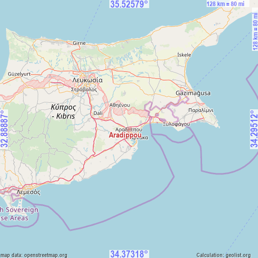
Aradíppou GPS coordinates[2]
34° 57' 5.436" North, 33° 35' 31.164" East
| Map corner | latitude | longitude |
|---|---|---|
| Upper-left | 35.52579°, | 32.88887° |
| Center: | 34.95151°, | 33.59199° |
| Lower-right: | 34.37318°, | 34.29512° |
| Map W x H: | 128.2×128.2 km | = 79.7×79.7mi |
| max Lat: | 35.59719° ⇑50.4% North |
| Aradíppou: | 34.95151° |
| min Lat: | ⇓49.6% South 34.66865° |
| min Long | Aradíppou | max Long |
| 32.38166° | 33.59199° | 34.37916° |
| W 80.3%⇐ | ⇒19.7% E |
Elevation
Elevation of Aradíppou is 53 m = 174 ft, and this is 155 m = 509 ft below average elevation for this country.
| Max E: |
1134 m = 3720 ft | 76.1% |
| Avg. | 208 m = 682 ft | |
| Aradíppou | 53 m = 174 ft | |
Min E: |
4 m = 13 ft | 23.9% |
See also: Cyprus elevation on elevation.city.
Geographical zone
Aradíppou is located in North temperate zone (between Tropic of Cancer and the Arctic Circle). Distance of this Northern Tropic circle is 1280.3 km =795.5 mi to South.| Distance of | km | miles | from Aradíppou |
|---|---|---|---|
| North Pole | 6120.8 | 3803.3 | to North |
| Arctic Circle | 3514.9 | 2184.1 | to North |
| Tropic Cancer | 1280.3 | 795.5 | to South |
| Equator | 3886.2 | 2414.8 | to South |


Nearby cities:
15 places around Aradíppou: (largest is in red/bold)
• Alethrikó
13.5 km =8.4 mi,  221°
221°
• Athíenou
13.1 km =8.1 mi,  339°
339°
• Dhromolaxia
8.5 km =5.3 mi,  183°
183°
• Kíti
11.7 km =7.3 mi,  188°
188°
• Larnaca
4.3 km =2.7 mi,  138°
138°
• Livádia
3.2 km =2 mi,  90°
90°
• Lýmpia
13 km =8.1 mi,  293°
293°
• Meneou
10.1 km =6.3 mi, 178°
• Perivólia
13.1 km =8.1 mi, 183°
• Psevdás
11.8 km =7.3 mi,  267°
267°
• Pérgamos
14.6 km =9.1 mi,  46°
46°
• Pýla
11.3 km =7 mi, 53°
• Tersefánou
11.6 km =7.2 mi,  200°
200°
• Troúlloi
9.2 km =5.7 mi,  13°
13°
• Voróklini
6.8 km =4.2 mi,  55°
55°
Sources, notices
• [Note1] Compared only with cities in Cyprus existing in our database
• [Src1] Map data: © OpenStreetMap contributors (CC-BY-SA)
• [Src2] Other city data from geonames.org with taken over terms of usage.
• [Src3] Geographical zone / Annual Mean Temperature by Robert A. Rohde @ Wikipedia
