Livádia geodata
Livádia (Larnaka) is a populated place; located in Cyprus in Asia/Nicosia (GMT+2) time zone. With population of 5,329 people, there are 18 cities with bigger population in this country. Compared to other cities in Cyprus, 51.3% of cities are located further ↑North; 83.8% of cities are located further ←West and 94.9% of cities have higher elevation than Livádia. Note1


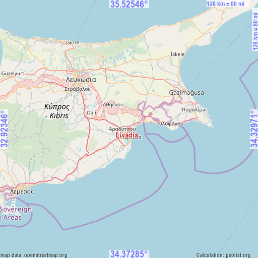
Livádia GPS coordinates[2]
34° 57' 4.248" North, 33° 37' 35.688" East
| Map corner | latitude | longitude |
|---|---|---|
| Upper-left | 35.52546°, | 32.92346° |
| Center: | 34.95118°, | 33.62658° |
| Lower-right: | 34.37285°, | 34.32971° |
| Map W x H: | 128.2×128.2 km | = 79.7×79.7mi |
| max Lat: | 35.59719° ⇑51.3% North |
| Livádia: | 34.95118° |
| min Lat: | ⇓48.7% South 34.66865° |
| min Long | Livádia | max Long |
| 32.38166° | 33.62658° | 34.37916° |
| W 83.8%⇐ | ⇒16.2% E |
Elevation
Elevation of Livádia is 15 m = 49 ft, and this is 193 m = 633 ft below average elevation for this country.
| Max E: |
1134 m = 3720 ft | 94.9% |
| Avg. | 208 m = 682 ft | |
| Livádia | 15 m = 49 ft | |
Min E: |
4 m = 13 ft | 5.1% |
See also: Cyprus elevation on elevation.city.
Geographical zone
Livádia is located in North temperate zone (between Tropic of Cancer and the Arctic Circle). Distance of this Northern Tropic circle is 1280.3 km =795.5 mi to South.| Distance of | km | miles | from Livádia |
|---|---|---|---|
| North Pole | 6120.9 | 3803.3 | to North |
| Arctic Circle | 3515 | 2184.1 | to North |
| Tropic Cancer | 1280.3 | 795.5 | to South |
| Equator | 3886.2 | 2414.8 | to South |


Nearby cities:
15 places around Livádia: (largest is in red/bold)
• Alethrikó
15.7 km =9.8 mi,  230°
230°
• Aradíppou
3.2 km =2 mi,  270°
270°
• Athíenou
14.5 km =9 mi,  327°
327°
• Dhromolaxia
9.2 km =5.7 mi,  203°
203°
• Kíti
12.6 km =7.8 mi, 202°
• Larnaca
3.2 km =2 mi,  185°
185°
• Meneou
10.4 km =6.5 mi, 195°
• Perivólia
13.7 km =8.5 mi, 197°
• Psevdás
14.9 km =9.3 mi, 268°
• Pérgamos
12.5 km =7.8 mi,  36°
36°
• Pýla
9 km =5.6 mi, 41°
• Tersefánou
13 km =8.1 mi,  213°
213°
• Troúlloi
9.1 km =5.7 mi,  353°
353°
• Voróklini
4.6 km =2.9 mi,  32°
32°
• Xylotymbou
12.9 km =8 mi,  55°
55°
Sources, notices
• [Note1] Compared only with cities in Cyprus existing in our database
• [Src1] Map data: © OpenStreetMap contributors (CC-BY-SA)
• [Src2] Other city data from geonames.org with taken over terms of usage.
• [Src3] Geographical zone / Annual Mean Temperature by Robert A. Rohde @ Wikipedia
