Xylotymbou geodata
Xylotymbou (Larnaka) is a populated place; located in Cyprus in Asia/Nicosia (GMT+2) time zone. With population of 3,593 people, there are 32 cities with bigger population in this country. Compared to other cities in Cyprus, 61.5% of cities are located further ↓South; 88% of cities are located further ←West and 73.5% of cities have higher elevation than Xylotymbou. Note1


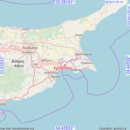
Xylotymbou GPS coordinates[2]
35° 1' 1.92" North, 33° 44' 32.82" East
| Map corner | latitude | longitude |
|---|---|---|
| Upper-left | 35.59101°, | 33.03933° |
| Center: | 35.0172°, | 33.74245° |
| Lower-right: | 34.43933°, | 34.44558° |
| Map W x H: | 128.1×128.1 km | = 79.6×79.6mi |
| max Lat: | 35.59719° ⇑38.5% North |
| Xylotymbou: | 35.0172° |
| min Lat: | ⇓61.5% South 34.66865° |
| min Long | Xylotymbou | max Long |
| 32.38166° | 33.74245° | 34.37916° |
| W 88%⇐ | ⇒12% E |
Elevation
Elevation of Xylotymbou is 60 m = 197 ft, and this is 148 m = 486 ft below average elevation for this country.
| Max E: |
1134 m = 3720 ft | 73.5% |
| Avg. | 208 m = 682 ft | |
| Xylotymbou | 60 m = 197 ft | |
Min E: |
4 m = 13 ft | 26.5% |
See also: Cyprus elevation on elevation.city.
Geographical zone
Xylotymbou is located in North temperate zone (between Tropic of Cancer and the Arctic Circle). Distance of this Northern Tropic circle is 1287.6 km =800.1 mi to South.| Distance of | km | miles | from Xylotymbou |
|---|---|---|---|
| North Pole | 6113.5 | 3798.8 | to North |
| Arctic Circle | 3507.6 | 2179.5 | to North |
| Tropic Cancer | 1287.6 | 800.1 | to South |
| Equator | 3893.5 | 2419.3 | to South |


Nearby cities:
15 places around Xylotymbou: (largest is in red/bold)
• Acherítou
14.2 km =8.8 mi,  49°
49°
• Aradíppou
15.5 km =9.6 mi,  241°
241°
• Athíenou
18.9 km =11.7 mi,  285°
285°
• Avgórou
9.1 km =5.7 mi,  76°
76°
• Derýneia
20.6 km =12.8 mi, 75°
• Frénaros
16.6 km =10.3 mi, 80°
• Larnaca
15.1 km =9.4 mi,  225°
225°
• Liopétri
13.7 km =8.5 mi,  93°
93°
• Livádia
12.9 km =8 mi, 235°
• Pérgamos
4.1 km =2.5 mi,  311°
311°
• Pýla
4.6 km =2.9 mi,  263°
263°
• Troúlloi
11.7 km =7.3 mi,  278°
278°
• Voróklini
8.8 km =5.5 mi,  246°
246°
• Xylofágou
10.7 km =6.6 mi,  114°
114°
• Áchna
5.7 km =3.5 mi,  41°
41°
Sources, notices
• [Note1] Compared only with cities in Cyprus existing in our database
• [Src1] Map data: © OpenStreetMap contributors (CC-BY-SA)
• [Src2] Other city data from geonames.org with taken over terms of usage.
• [Src3] Geographical zone / Annual Mean Temperature by Robert A. Rohde @ Wikipedia
