Pérgamos geodata
Pérgamos (Larnaka) is a populated place; located in Cyprus in Asia/Nicosia (GMT+2) time zone. With population of 15,000 people, there are 7 cities with bigger population in this country. Compared to other cities in Cyprus, 70.9% of cities are located further ↓South; 86.3% of cities are located further ←West and 60.7% of cities have higher elevation than Pérgamos. Note1


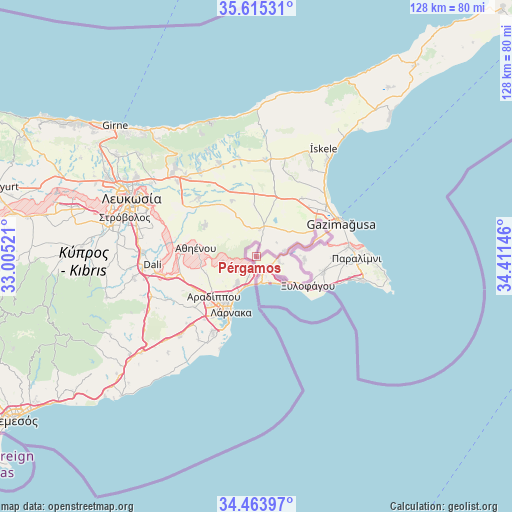
Pérgamos GPS coordinates[2]
35° 2' 30.012" North, 33° 42' 29.988" East
| Map corner | latitude | longitude |
|---|---|---|
| Upper-left | 35.61531°, | 33.00521° |
| Center: | 35.04167°, | 33.70833° |
| Lower-right: | 34.46397°, | 34.41146° |
| Map W x H: | 128×128 km | = 79.5×79.5mi |
| max Lat: | 35.59719° ⇑29.1% North |
| Pérgamos: | 35.04167° |
| min Lat: | ⇓70.9% South 34.66865° |
| min Long | Pérgamos | max Long |
| 32.38166° | 33.70833° | 34.37916° |
| W 86.3%⇐ | ⇒13.7% E |
Elevation
Elevation of Pérgamos is 85 m = 279 ft, and this is 123 m = 404 ft below average elevation for this country.
| Max E: |
1134 m = 3720 ft | 60.7% |
| Avg. | 208 m = 682 ft | |
| Pérgamos | 85 m = 279 ft | |
Min E: |
4 m = 13 ft | 39.3% |
See also: Cyprus elevation on elevation.city.
Geographical zone
Pérgamos is located in North temperate zone (between Tropic of Cancer and the Arctic Circle). Distance of this Northern Tropic circle is 1290.3 km =801.8 mi to South.| Distance of | km | miles | from Pérgamos |
|---|---|---|---|
| North Pole | 6110.8 | 3797.1 | to North |
| Arctic Circle | 3504.9 | 2177.8 | to North |
| Tropic Cancer | 1290.3 | 801.8 | to South |
| Equator | 3896.3 | 2421 | to South |


Nearby cities:
15 places around Pérgamos: (largest is in red/bold)
• Acherítou
15.4 km =9.6 mi,  64°
64°
• Aradíppou
14.6 km =9.1 mi,  226°
226°
• Athíenou
15.3 km =9.5 mi,  278°
278°
• Avgórou
11.9 km =7.4 mi,  92°
92°
• Dhromolaxia
21.5 km =13.4 mi,  210°
210°
• Frénaros
19.5 km =12.1 mi, 90°
• Larnaca
15.3 km =9.5 mi, 210°
• Liopétri
17.2 km =10.7 mi,  102°
102°
• Livádia
12.5 km =7.8 mi,  216°
216°
• Pýla
3.6 km =2.2 mi,  204°
204°
• Troúlloi
8.6 km =5.3 mi,  262°
262°
• Voróklini
7.9 km =4.9 mi, 218°
• Xylofágou
14.7 km =9.1 mi,  119°
119°
• Xylotymbou
4.1 km =2.5 mi,  131°
131°
• Áchna
7 km =4.3 mi,  77°
77°
Sources, notices
• [Note1] Compared only with cities in Cyprus existing in our database
• [Src1] Map data: © OpenStreetMap contributors (CC-BY-SA)
• [Src2] Other city data from geonames.org with taken over terms of usage.
• [Src3] Geographical zone / Annual Mean Temperature by Robert A. Rohde @ Wikipedia
