Auerbach geodata
Auerbach (Saxony) is a seat of a fourth-order administrative division; located in Germany in Europe/Berlin (GMT+2) time zone. In our database, there are 11009 cities with bigger population. Compared to other cities in Germany, 51.6% of cities are located further ↓South; 91.6% of cities are located further ←West and 93.4% of cities have lower elevation than Auerbach. Note1


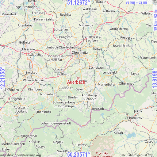
Auerbach GPS coordinates[2]
50° 40' 59.988" North, 12° 55' 0.012" East
| Map corner | latitude | longitude |
|---|---|---|
| Upper-left | 51.12672°, | 12.21355° |
| Center: | 50.68333°, | 12.91667° |
| Lower-right: | 50.23571°, | 13.6198° |
| Map W x H: | 99.1×99.1 km | = 61.6×61.6mi |
| max Lat: | 55.01917° ⇑48.4% North |
| Auerbach: | 50.68333° |
| min Lat: | ⇓51.6% South 47.40724° |
| min Long | Auerbach | max Long |
| 5.92978° | 12.91667° | 14.98853° |
| W 91.6%⇐ | ⇒8.4% E |
Elevation
Elevation of Auerbach is 564 m = 1850 ft, and this is 314.9 m = 1033 ft above average elevation for this country.
| Max E: |
1256 m = 4121 ft | 6.6% |
| Auerbach | 564 m 1850 ft | |
| Avg. | 249.1 m = 817 ft | |
Min E: |
-5 m = -16 ft | 93.4% |
See also: Germany elevation on elevation.city.
Geographical zone
Auerbach is located in North temperate zone (between Tropic of Cancer and the Arctic Circle). Distance of this North polar circle is 1765.7 km =1097.2 mi to North.| Distance of | km | miles | from Auerbach |
|---|---|---|---|
| North Pole | 4371.6 | 2716.4 | to North |
| Arctic Circle | 1765.7 | 1097.2 | to North |
| Tropic Cancer | 3029.5 | 1882.4 | to South |
| Equator | 5635.5 | 3501.7 | to South |


Nearby cities:
15 places around Auerbach: (largest is in red/bold)
• Burkhardtsdorf
5.6 km =3.5 mi,  0°
0°
• Dorfchemnitz
6.1 km =3.8 mi,  248°
248°
• Drebach
7.1 km =4.4 mi,  96°
96°
• Ehrenfriedersdorf
5.3 km =3.3 mi,  135°
135°
• Gelenau
4.7 km =2.9 mi,  48°
48°
• Geyer
6.3 km =3.9 mi,  177°
177°
• Gornsdorf
3 km =1.9 mi,  308°
308°
• Hormersdorf
2.7 km =1.7 mi, 247°
• Jahnsdorf
8.2 km =5.1 mi,  327°
327°
• Stollberg
10 km =6.2 mi,  287°
287°
• Tannenberg
8.6 km =5.3 mi,  169°
169°
• Thalheim
5.1 km =3.2 mi, 292°
• Thum
2.8 km =1.7 mi,  119°
119°
• Venusberg
7.4 km =4.6 mi,  76°
76°
• Zwönitz
9.6 km =6 mi,  231°
231°
Sources, notices
• [Note1] Compared only with cities in Germany existing in our database
• [Src1] Map data: © OpenStreetMap contributors (CC-BY-SA)
• [Src2] Other city data from geonames.org with taken over terms of usage.
• [Src3] Geographical zone / Annual Mean Temperature by Robert A. Rohde @ Wikipedia
