Tannenberg geodata
Tannenberg (Saxony) is a seat of a fourth-order administrative division; located in Germany in Europe/Berlin (GMT+2) time zone. With population of 1,283 people, there are 6354 cities with bigger population in this country. Compared to other cities in Germany, 50.3% of cities are located further ↑North; 91.8% of cities are located further ←West and 90.9% of cities have lower elevation than Tannenberg. Note1


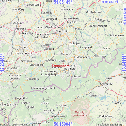
Tannenberg GPS coordinates[2]
50° 36' 26.568" North, 12° 56' 16.728" East
| Map corner | latitude | longitude |
|---|---|---|
| Upper-left | 51.05149°, | 12.23486° |
| Center: | 50.60738°, | 12.93798° |
| Lower-right: | 50.15904°, | 13.64111° |
| Map W x H: | 99.2×99.2 km | = 61.6×61.6mi |
| max Lat: | 55.01917° ⇑50.3% North |
| Tannenberg: | 50.60738° |
| min Lat: | ⇓49.7% South 47.40724° |
| min Long | Tannenberg | max Long |
| 5.92978° | 12.93798° | 14.98853° |
| W 91.8%⇐ | ⇒8.2% E |
Elevation
Elevation of Tannenberg is 526 m = 1726 ft, and this is 276.9 m = 908 ft above average elevation for this country.
| Max E: |
1256 m = 4121 ft | 9.1% |
| Tannenberg | 526 m 1726 ft | |
| Avg. | 249.1 m = 817 ft | |
Min E: |
-5 m = -16 ft | 90.9% |
See also: Germany elevation on elevation.city.
Geographical zone
Tannenberg is located in North temperate zone (between Tropic of Cancer and the Arctic Circle). Distance of this North polar circle is 1774.2 km =1102.4 mi to North.| Distance of | km | miles | from Tannenberg |
|---|---|---|---|
| North Pole | 4380 | 2721.6 | to North |
| Arctic Circle | 1774.2 | 1102.4 | to North |
| Tropic Cancer | 3021.1 | 1877.2 | to South |
| Equator | 5627 | 3496.5 | to South |


Nearby cities:
15 places around Tannenberg: (largest is in red/bold)
• Annaberg-Buchholz
5.7 km =3.5 mi,  122°
122°
• Auerbach
8.6 km =5.3 mi,  349°
349°
• Dorfchemnitz
9.5 km =5.9 mi,  311°
311°
• Drebach
9.4 km =5.8 mi,  35°
35°
• Ehrenfriedersdorf
5.2 km =3.2 mi,  25°
25°
• Elterlein
6 km =3.7 mi,  235°
235°
• Geyer
2.4 km =1.5 mi,  329°
329°
• Hormersdorf
8.4 km =5.2 mi, 331°
• Markersbach
9.7 km =6 mi,  214°
214°
• Scheibenberg
7.7 km =4.8 mi,  193°
193°
• Schlettau
5.5 km =3.4 mi,  169°
169°
• Thermalbad Wiesenbad
8 km =5 mi,  82°
82°
• Thum
7.1 km =4.4 mi,  7°
7°
• Wiesa
5.4 km =3.4 mi,  85°
85°
• Zwönitz
9.4 km =5.8 mi,  285°
285°
Sources, notices
• [Note1] Compared only with cities in Germany existing in our database
• [Src1] Map data: © OpenStreetMap contributors (CC-BY-SA)
• [Src2] Other city data from geonames.org with taken over terms of usage.
• [Src3] Geographical zone / Annual Mean Temperature by Robert A. Rohde @ Wikipedia
