Geyer geodata
Geyer (Saxony) is a populated place; located in Germany in Europe/Berlin (GMT+2) time zone. With population of 4,118 people, there are 3216 cities with bigger population in this country. Compared to other cities in Germany, 50.2% of cities are located further ↓South; 91.6% of cities are located further ←West and 95.5% of cities have lower elevation than Geyer. Note1


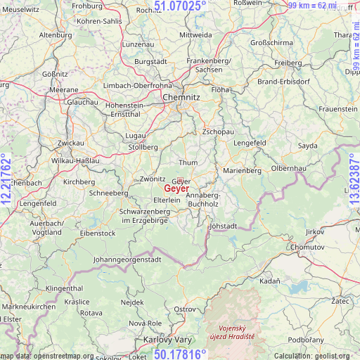
Geyer GPS coordinates[2]
50° 37' 34.752" North, 12° 55' 14.664" East
| Map corner | latitude | longitude |
|---|---|---|
| Upper-left | 51.07025°, | 12.21762° |
| Center: | 50.62632°, | 12.92074° |
| Lower-right: | 50.17816°, | 13.62387° |
| Map W x H: | 99.2×99.2 km | = 61.6×61.6mi |
| max Lat: | 55.01917° ⇑49.8% North |
| Geyer: | 50.62632° |
| min Lat: | ⇓50.2% South 47.40724° |
| min Long | Geyer | max Long |
| 5.92978° | 12.92074° | 14.98853° |
| W 91.6%⇐ | ⇒8.4% E |
Elevation
Elevation of Geyer is 610 m = 2001 ft, and this is 360.9 m = 1184 ft above average elevation for this country.
| Max E: |
1256 m = 4121 ft | 4.5% |
| Geyer | 610 m 2001 ft | |
| Avg. | 249.1 m = 817 ft | |
Min E: |
-5 m = -16 ft | 95.5% |
See also: Germany elevation on elevation.city.
Geographical zone
Geyer is located in North temperate zone (between Tropic of Cancer and the Arctic Circle). Distance of this North polar circle is 1772.1 km =1101.1 mi to North.| Distance of | km | miles | from Geyer |
|---|---|---|---|
| North Pole | 4377.9 | 2720.3 | to North |
| Arctic Circle | 1772.1 | 1101.1 | to North |
| Tropic Cancer | 3023.2 | 1878.5 | to South |
| Equator | 5629.1 | 3497.8 | to South |


Nearby cities:
15 places around Geyer: (largest is in red/bold)
• Annaberg-Buchholz
8 km =5 mi,  130°
130°
• Auerbach
6.3 km =3.9 mi,  357°
357°
• Dorfchemnitz
7.2 km =4.5 mi,  304°
304°
• Drebach
8.7 km =5.4 mi,  50°
50°
• Ehrenfriedersdorf
4.3 km =2.7 mi, 53°
• Elterlein
6.6 km =4.1 mi,  213°
213°
• Gornsdorf
8.6 km =5.3 mi,  342°
342°
• Grünhain
9.5 km =5.9 mi,  237°
237°
• Hormersdorf
6 km =3.7 mi,  332°
332°
• Schlettau
7.8 km =4.8 mi,  163°
163°
• Tannenberg
2.4 km =1.5 mi,  149°
149°
• Thermalbad Wiesenbad
9.2 km =5.7 mi,  96°
96°
• Thum
5.4 km =3.4 mi,  23°
23°
• Wiesa
6.8 km =4.2 mi, 104°
• Zwönitz
7.8 km =4.8 mi,  273°
273°
Sources, notices
• [Note1] Compared only with cities in Germany existing in our database
• [Src1] Map data: © OpenStreetMap contributors (CC-BY-SA)
• [Src2] Other city data from geonames.org with taken over terms of usage.
• [Src3] Geographical zone / Annual Mean Temperature by Robert A. Rohde @ Wikipedia
