Leisnig geodata
Leisnig (Saxony) is a populated place; located in Germany in Europe/Berlin (GMT+2) time zone. With population of 6,968 people, there are 2190 cities with bigger population in this country. Compared to other cities in Germany, 60.9% of cities are located further ↓South; 91.7% of cities are located further ←West and 50.5% of cities have higher elevation than Leisnig. Note1


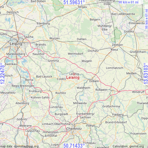
Leisnig GPS coordinates[2]
51° 9' 26.748" North, 12° 55' 40.44" East
| Map corner | latitude | longitude |
|---|---|---|
| Upper-left | 51.59631°, | 12.22478° |
| Center: | 51.15743°, | 12.9279° |
| Lower-right: | 50.71433°, | 13.63103° |
| Map W x H: | 98.1×98.1 km | = 61×61mi |
| max Lat: | 55.01917° ⇑39.1% North |
| Leisnig: | 51.15743° |
| min Lat: | ⇓60.9% South 47.40724° |
| min Long | Leisnig | max Long |
| 5.92978° | 12.9279° | 14.98853° |
| W 91.7%⇐ | ⇒8.3% E |
Elevation
Elevation of Leisnig is 221 m = 725 ft, and this is 28.1 m = 92 ft below average elevation for this country.
| Max E: |
1256 m = 4121 ft | 50.5% |
| Avg. | 249.1 m = 817 ft | |
| Leisnig | 221 m = 725 ft | |
Min E: |
-5 m = -16 ft | 49.5% |
See also: Germany elevation on elevation.city.
Geographical zone
Leisnig is located in North temperate zone (between Tropic of Cancer and the Arctic Circle). Distance of this North polar circle is 1713 km =1064.4 mi to North.| Distance of | km | miles | from Leisnig |
|---|---|---|---|
| North Pole | 4318.9 | 2683.6 | to North |
| Arctic Circle | 1713 | 1064.4 | to North |
| Tropic Cancer | 3082.3 | 1915.3 | to South |
| Equator | 5688.2 | 3534.5 | to South |


Nearby cities:
15 places around Leisnig: (largest is in red/bold)
• Bockelwitz
5.1 km =3.2 mi,  22°
22°
• Colditz
9.3 km =5.8 mi,  249°
249°
• Döbeln
13.3 km =8.3 mi,  107°
107°
• Geringswalde
9.1 km =5.7 mi,  189°
189°
• Gersdorf
5.1 km =3.2 mi,  171°
171°
• Großbothen
12.8 km =8 mi,  285°
285°
• Großweitzschen
8.2 km =5.1 mi,  89°
89°
• Hartha
7.3 km =4.5 mi,  153°
153°
• Kriebstein
13.5 km =8.4 mi, 152°
• Mutzschen
11.9 km =7.4 mi,  347°
347°
• Mügeln
12 km =7.5 mi,  43°
43°
• Ostrau
6.2 km =3.9 mi,  330°
330°
• Waldheim
11.4 km =7.1 mi, 145°
• Zettlitz
12.1 km =7.5 mi,  213°
213°
• Zschadrass
7.9 km =4.9 mi, 254°
Sources, notices
• [Note1] Compared only with cities in Germany existing in our database
• [Src1] Map data: © OpenStreetMap contributors (CC-BY-SA)
• [Src2] Other city data from geonames.org with taken over terms of usage.
• [Src3] Geographical zone / Annual Mean Temperature by Robert A. Rohde @ Wikipedia
