Rochlitz geodata
Rochlitz (Saxony) is a populated place; located in Germany in Europe/Berlin (GMT+2) time zone. With population of 6,847 people, there are 2220 cities with bigger population in this country. Compared to other cities in Germany, 59% of cities are located further ↓South; 90.7% of cities are located further ←West and 58.1% of cities have higher elevation than Rochlitz. Note1


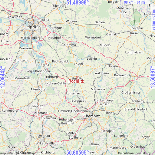
Rochlitz GPS coordinates[2]
51° 3' 0.252" North, 12° 47' 51.144" East
| Map corner | latitude | longitude |
|---|---|---|
| Upper-left | 51.48998°, | 12.09442° |
| Center: | 51.05007°, | 12.79754° |
| Lower-right: | 50.60595°, | 13.50067° |
| Map W x H: | 98.3×98.3 km | = 61.1×61.1mi |
| max Lat: | 55.01917° ⇑41% North |
| Rochlitz: | 51.05007° |
| min Lat: | ⇓59% South 47.40724° |
| min Long | Rochlitz | max Long |
| 5.92978° | 12.79754° | 14.98853° |
| W 90.7%⇐ | ⇒9.3% E |
Elevation
Elevation of Rochlitz is 167 m = 548 ft, and this is 82.1 m = 269 ft below average elevation for this country.
| Max E: |
1256 m = 4121 ft | 58.1% |
| Avg. | 249.1 m = 817 ft | |
| Rochlitz | 167 m = 548 ft | |
Min E: |
-5 m = -16 ft | 41.9% |
See also: Germany elevation on elevation.city.
Geographical zone
Rochlitz is located in North temperate zone (between Tropic of Cancer and the Arctic Circle). Distance of this North polar circle is 1724.9 km =1071.8 mi to North.| Distance of | km | miles | from Rochlitz |
|---|---|---|---|
| North Pole | 4330.8 | 2691 | to North |
| Arctic Circle | 1724.9 | 1071.8 | to North |
| Tropic Cancer | 3070.3 | 1907.8 | to South |
| Equator | 5676.2 | 3527 | to South |


Nearby cities:
15 places around Rochlitz: (largest is in red/bold)
• Altmittweida
14.1 km =8.8 mi,  131°
131°
• Colditz
8.7 km =5.4 mi,  2°
2°
• Erlau
11.3 km =7 mi,  113°
113°
• Geithain
7.1 km =4.4 mi,  274°
274°
• Geringswalde
8.2 km =5.1 mi,  68°
68°
• Gersdorf
12.1 km =7.5 mi,  55°
55°
• Hartha
13.5 km =8.4 mi, 66°
• Königsfeld
3.8 km =2.4 mi,  299°
299°
• Lunzenau
10.1 km =6.3 mi,  196°
196°
• Mittweida
14.3 km =8.9 mi,  119°
119°
• Narsdorf
6.8 km =4.2 mi,  236°
236°
• Seelitz
2.3 km =1.4 mi,  144°
144°
• Wechselburg
5.5 km =3.4 mi, 195°
• Zettlitz
3.1 km =1.9 mi,  53°
53°
• Zschadrass
9.9 km =6.2 mi,  8°
8°
Sources, notices
• [Note1] Compared only with cities in Germany existing in our database
• [Src1] Map data: © OpenStreetMap contributors (CC-BY-SA)
• [Src2] Other city data from geonames.org with taken over terms of usage.
• [Src3] Geographical zone / Annual Mean Temperature by Robert A. Rohde @ Wikipedia
