Geringswalde geodata
Geringswalde (Saxony) is a populated place; located in Germany in Europe/Berlin (GMT+2) time zone. With population of 5,125 people, there are 2778 cities with bigger population in this country. Compared to other cities in Germany, 59.5% of cities are located further ↓South; 91.5% of cities are located further ←West and 54.1% of cities have lower elevation than Geringswalde. Note1


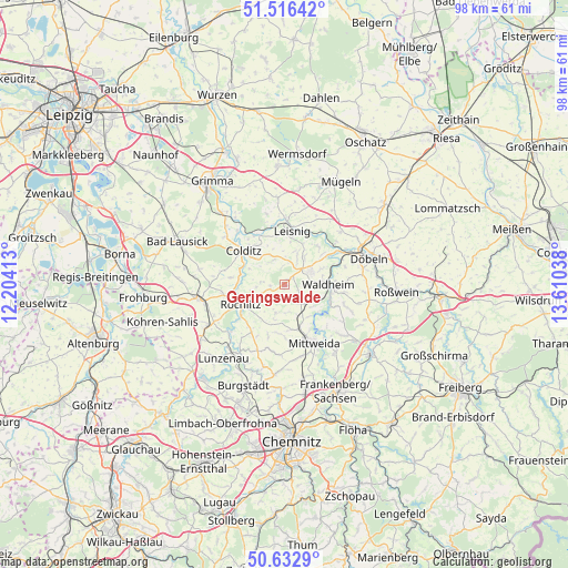
Geringswalde GPS coordinates[2]
51° 4' 36.372" North, 12° 54' 26.1" East
| Map corner | latitude | longitude |
|---|---|---|
| Upper-left | 51.51642°, | 12.20413° |
| Center: | 51.07677°, | 12.90725° |
| Lower-right: | 50.6329°, | 13.61038° |
| Map W x H: | 98.2×98.2 km | = 61×61mi |
| max Lat: | 55.01917° ⇑40.5% North |
| Geringswalde: | 51.07677° |
| min Lat: | ⇓59.5% South 47.40724° |
| min Long | Geringswalde | max Long |
| 5.92978° | 12.90725° | 14.98853° |
| W 91.5%⇐ | ⇒8.5% E |
Elevation
Elevation of Geringswalde is 252 m = 827 ft, and this is 2.9 m = 10 ft above average elevation for this country.
| Max E: |
1256 m = 4121 ft | 45.9% |
| Geringswalde | 252 m 827 ft | |
| Avg. | 249.1 m = 817 ft | |
Min E: |
-5 m = -16 ft | 54.1% |
See also: Germany elevation on elevation.city.
Geographical zone
Geringswalde is located in North temperate zone (between Tropic of Cancer and the Arctic Circle). Distance of this North polar circle is 1722 km =1070 mi to North.| Distance of | km | miles | from Geringswalde |
|---|---|---|---|
| North Pole | 4327.9 | 2689.2 | to North |
| Arctic Circle | 1722 | 1070 | to North |
| Tropic Cancer | 3073.3 | 1909.7 | to South |
| Equator | 5679.2 | 3528.9 | to South |


Nearby cities:
15 places around Geringswalde: (largest is in red/bold)
• Altmittweida
12.6 km =7.8 mi,  166°
166°
• Colditz
9.3 km =5.8 mi,  308°
308°
• Erlau
8 km =5 mi,  160°
160°
• Gersdorf
4.5 km =2.8 mi,  29°
29°
• Hartha
5.3 km =3.3 mi,  62°
62°
• Kriebstein
8.2 km =5.1 mi,  111°
111°
• Königsfeld
11 km =6.8 mi,  264°
264°
• Leisnig
9.1 km =5.7 mi,  9°
9°
• Mittweida
11.1 km =6.9 mi,  154°
154°
• Rochlitz
8.2 km =5.1 mi,  248°
248°
• Seelitz
8 km =5 mi,  232°
232°
• Waldheim
7.9 km =4.9 mi,  93°
93°
• Wechselburg
12.3 km =7.6 mi, 227°
• Zettlitz
5.3 km =3.3 mi, 257°
• Zschadrass
9.2 km =5.7 mi,  317°
317°
Sources, notices
• [Note1] Compared only with cities in Germany existing in our database
• [Src1] Map data: © OpenStreetMap contributors (CC-BY-SA)
• [Src2] Other city data from geonames.org with taken over terms of usage.
• [Src3] Geographical zone / Annual Mean Temperature by Robert A. Rohde @ Wikipedia
