Leimersheim geodata
Leimersheim (Rheinland-Pfalz) is a seat of a fourth-order administrative division; located in Germany in Europe/Berlin (GMT+2) time zone. With population of 2,624 people, there are 4308 cities with bigger population in this country. Compared to other cities in Germany, 81.4% of cities are located further ↑North; 72.4% of cities are located further →East and 67.8% of cities have higher elevation than Leimersheim. Note1
Administrative division(s):
- Level 1: Rheinland-Pfalz
- Level 3: Landkreis Germersheim
- Level 4: Leimersheim


Leimersheim GPS coordinates[2]
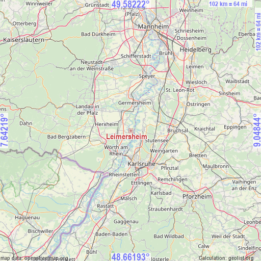
49° 7' 27.156" North, 8° 20' 43.116" East
| Map corner | latitude | longitude |
|---|---|---|
| Upper-left | 49.58222°, | 7.64219° |
| Center: | 49.12421°, | 8.34531° |
| Lower-right: | 48.66193°, | 9.04844° |
| Map W x H: | 102.3×102.3 km | = 63.6×63.6mi |
| max Lat: | 55.01917° ⇑81.4% North |
| Leimersheim: | 49.12421° |
| min Lat: | ⇓18.6% South 47.40724° |
| min Long | Leimersheim | max Long |
| 5.92978° | 8.34531° | 14.98853° |
| W 27.6%⇐ | ⇒72.4% E |
Elevation
Elevation of Leimersheim is 103 m = 338 ft, and this is 146.1 m = 479 ft below average elevation for this country.
| Max E: |
1256 m = 4121 ft | 67.8% |
| Avg. | 249.1 m = 817 ft | |
| Leimersheim | 103 m = 338 ft | |
Min E: |
-5 m = -16 ft | 32.2% |
See also: Germany elevation on elevation.city.
Geographical zone
Leimersheim is located in North temperate zone (between Tropic of Cancer and the Arctic Circle). Distance of this North polar circle is 1939.1 km =1204.9 mi to North.| Distance of | km | miles | from Leimersheim |
|---|---|---|---|
| North Pole | 4545 | 2824.1 | to North |
| Arctic Circle | 1939.1 | 1204.9 | to North |
| Tropic Cancer | 2856.2 | 1774.8 | to South |
| Equator | 5462.1 | 3394 | to South |


Nearby cities:
15 places around Leimersheim: (largest is in red/bold)
• Bellheim
9.5 km =5.9 mi,  329°
329°
• Eggenstein-Leopoldshafen
5.4 km =3.4 mi,  134°
134°
• Germersheim
11.1 km =6.9 mi,  7°
7°
• Hatzenbühl
7.4 km =4.6 mi,  258°
258°
• Herxheim
9.9 km =6.2 mi,  284°
284°
• Herxheimweyher
7.3 km =4.5 mi,  295°
295°
• Hördt
4.8 km =3 mi,  343°
343°
• Jockgrim
6.2 km =3.9 mi,  235°
235°
• Knittelsheim
10.1 km =6.3 mi,  317°
317°
• Kuhardt
3.3 km =2.1 mi, 316°
• Linkenheim-Hochstetten
5 km =3.1 mi,  79°
79°
• Neupotz
2 km =1.2 mi,  249°
249°
• Rheinzabern
4.9 km =3 mi, 262°
• Rülzheim
5 km =3.1 mi,  310°
310°
• Wörth am Rhein
10.4 km =6.5 mi,  216°
216°
Sources, notices
• [Note1] Compared only with cities in Germany existing in our database
• [Src1] Map data: © OpenStreetMap contributors (CC-BY-SA)
• [Src2] Other city data from geonames.org with taken over terms of usage.
• [Src3] Geographical zone / Annual Mean Temperature by Robert A. Rohde @ Wikipedia
