Hatzenbühl geodata
Hatzenbühl (Rheinland-Pfalz) is a seat of a fourth-order administrative division; located in Germany in Europe/Berlin (GMT+2) time zone. With population of 2,693 people, there are 4238 cities with bigger population in this country. Compared to other cities in Germany, 81.6% of cities are located further ↑North; 73.5% of cities are located further →East and 65.6% of cities have higher elevation than Hatzenbühl. Note1
Administrative division(s):
- Level 1: Rheinland-Pfalz
- Level 3: Landkreis Germersheim
- Level 4: Hatzenbühl


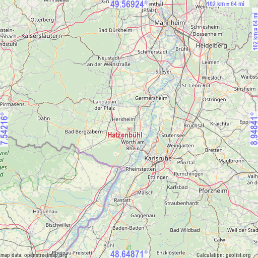
Hatzenbühl GPS coordinates[2]
49° 6' 39.996" North, 8° 14' 43.008" East
| Map corner | latitude | longitude |
|---|---|---|
| Upper-left | 49.56924°, | 7.54216° |
| Center: | 49.11111°, | 8.24528° |
| Lower-right: | 48.64871°, | 8.94841° |
| Map W x H: | 102.4×102.4 km | = 63.6×63.6mi |
| max Lat: | 55.01917° ⇑81.6% North |
| Hatzenbühl: | 49.11111° |
| min Lat: | ⇓18.4% South 47.40724° |
| min Long | Hatzenbühl | max Long |
| 5.92978° | 8.24528° | 14.98853° |
| W 26.5%⇐ | ⇒73.5% E |
Elevation
Elevation of Hatzenbühl is 117 m = 384 ft, and this is 132.1 m = 433 ft below average elevation for this country.
| Max E: |
1256 m = 4121 ft | 65.6% |
| Avg. | 249.1 m = 817 ft | |
| Hatzenbühl | 117 m = 384 ft | |
Min E: |
-5 m = -16 ft | 34.4% |
See also: Germany elevation on elevation.city.
Geographical zone
Hatzenbühl is located in North temperate zone (between Tropic of Cancer and the Arctic Circle). Distance of this North polar circle is 1940.5 km =1205.8 mi to North.| Distance of | km | miles | from Hatzenbühl |
|---|---|---|---|
| North Pole | 4546.4 | 2825 | to North |
| Arctic Circle | 1940.5 | 1205.8 | to North |
| Tropic Cancer | 2854.7 | 1773.8 | to South |
| Equator | 5460.6 | 3393.1 | to South |


Nearby cities:
15 places around Hatzenbühl: (largest is in red/bold)
• Erlenbach
4.2 km =2.6 mi,  269°
269°
• Herxheim
4.5 km =2.8 mi,  329°
329°
• Herxheimweyher
4.7 km =2.9 mi,  8°
8°
• Hördt
8.5 km =5.3 mi,  44°
44°
• Insheim
8.8 km =5.5 mi,  306°
306°
• Jockgrim
2.9 km =1.8 mi,  133°
133°
• Kandel
4.7 km =2.9 mi,  228°
228°
• Kuhardt
6.3 km =3.9 mi,  52°
52°
• Leimersheim
7.4 km =4.6 mi,  78°
78°
• Minfeld
8.5 km =5.3 mi,  238°
238°
• Neupotz
5.4 km =3.4 mi, 82°
• Rheinzabern
2.5 km =1.6 mi,  72°
72°
• Rülzheim
5.8 km =3.6 mi, 36°
• Steinweiler
7.6 km =4.7 mi,  278°
278°
• Wörth am Rhein
7 km =4.3 mi,  171°
171°
Sources, notices
• [Note1] Compared only with cities in Germany existing in our database
• [Src1] Map data: © OpenStreetMap contributors (CC-BY-SA)
• [Src2] Other city data from geonames.org with taken over terms of usage.
• [Src3] Geographical zone / Annual Mean Temperature by Robert A. Rohde @ Wikipedia
