Wolfsburg geodata
Wolfsburg (Lower Saxony) is a seat of a third-order administrative division; located in Germany in Europe/Berlin (GMT+2) time zone. With population of 123,064 people, there are 69 cities with bigger population in this country. Compared to other cities in Germany, 76.5% of cities are located further ↓South; 63.7% of cities are located further ←West and 75.3% of cities have higher elevation than Wolfsburg. Note1
Administrative division(s):
- Level 1: Lower Saxony
- Level 3: Kreisfreie Stadt Wolfsburg
- Level 4: Wolfsburg


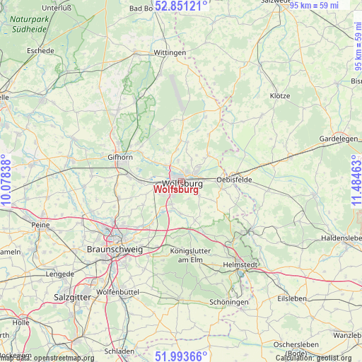
Wolfsburg GPS coordinates[2]
52° 25' 28.272" North, 10° 46' 53.4" East
| Map corner | latitude | longitude |
|---|---|---|
| Upper-left | 52.85121°, | 10.07838° |
| Center: | 52.42452°, | 10.7815° |
| Lower-right: | 51.99366°, | 11.48463° |
| Map W x H: | 95.4×95.3 km | = 59.3×59.2mi |
| max Lat: | 55.01917° ⇑23.5% North |
| Wolfsburg: | 52.42452° |
| min Lat: | ⇓76.5% South 47.40724° |
| min Long | Wolfsburg | max Long |
| 5.92978° | 10.7815° | 14.98853° |
| W 63.7%⇐ | ⇒36.3% E |
Elevation
Elevation of Wolfsburg is 62 m = 203 ft, and this is 187.1 m = 614 ft below average elevation for this country.
| Max E: |
1256 m = 4121 ft | 75.3% |
| Avg. | 249.1 m = 817 ft | |
| Wolfsburg | 62 m = 203 ft | |
Min E: |
-5 m = -16 ft | 24.7% |
See also: Wolfsburg elevation on elevation.city.
Geographical zone
Wolfsburg is located in North temperate zone (between Tropic of Cancer and the Arctic Circle). Distance of this North polar circle is 1572.1 km =976.9 mi to North.| Distance of | km | miles | from Wolfsburg |
|---|---|---|---|
| North Pole | 4178 | 2596.1 | to North |
| Arctic Circle | 1572.1 | 976.9 | to North |
| Tropic Cancer | 3223.1 | 2002.7 | to South |
| Equator | 5829.1 | 3622 | to South |


Nearby cities:
15 places around Wolfsburg: (largest is in red/bold)
• Allerbüttel
9.7 km =6 mi,  267°
267°
• Barwedel
10.8 km =6.7 mi,  357°
357°
• Bokensdorf
9.5 km =5.9 mi,  332°
332°
• Calberlah
10.7 km =6.6 mi, 267°
• Danndorf
8.9 km =5.5 mi,  89°
89°
• Detmerode
4.6 km =2.9 mi,  213°
213°
• Jembke
8.5 km =5.3 mi,  353°
353°
• Osloß
8.5 km =5.3 mi,  305°
305°
• Rothenfelde
0.9 km =0.6 mi,  71°
71°
• Rühen
9.8 km =6.1 mi,  46°
46°
• Tappenbeck
5.8 km =3.6 mi, 331°
• Tiddische
10.3 km =6.4 mi,  6°
6°
• Velpke
10.7 km =6.6 mi,  99°
99°
• Westhagen
3.6 km =2.2 mi,  231°
231°
• Weyhausen
6 km =3.7 mi, 313°
In other languages:
- In Spanish: Wolfsburgo
- In France: Wolfsbourg
- In Russian: Вольфсбург
- In Chinese: 沃尔夫斯堡
Sources, notices
• [Note1] Compared only with cities in Germany existing in our database
• [Src1] Map data: © OpenStreetMap contributors (CC-BY-SA)
• [Src2] Other city data from geonames.org with taken over terms of usage.
• [Src3] Geographical zone / Annual Mean Temperature by Robert A. Rohde @ Wikipedia
