Westhagen geodata
Westhagen (Lower Saxony) is a section of populated place; located in Germany in Europe/Berlin (GMT+2) time zone. With population of 9,206 people, there are 1753 cities with bigger population in this country. Compared to other cities in Germany, 76.2% of cities are located further ↓South; 63.1% of cities are located further ←West and 66.7% of cities have higher elevation than Westhagen. Note1
Administrative division(s):
- Level 1: Lower Saxony
- Level 3: Kreisfreie Stadt Wolfsburg
- Level 4: Wolfsburg


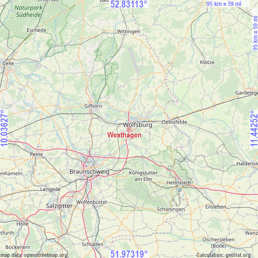
Westhagen GPS coordinates[2]
52° 24' 15.3" North, 10° 44' 21.804" East
| Map corner | latitude | longitude |
|---|---|---|
| Upper-left | 52.83113°, | 10.03627° |
| Center: | 52.40425°, | 10.73939° |
| Lower-right: | 51.97319°, | 11.44252° |
| Map W x H: | 95.4×95.4 km | = 59.3×59.3mi |
| max Lat: | 55.01917° ⇑23.8% North |
| Westhagen: | 52.40425° |
| min Lat: | ⇓76.2% South 47.40724° |
| min Long | Westhagen | max Long |
| 5.92978° | 10.73939° | 14.98853° |
| W 63.1%⇐ | ⇒36.9% E |
Elevation
Elevation of Westhagen is 110 m = 361 ft, and this is 139.1 m = 456 ft below average elevation for this country.
| Max E: |
1256 m = 4121 ft | 66.7% |
| Avg. | 249.1 m = 817 ft | |
| Westhagen | 110 m = 361 ft | |
Min E: |
-5 m = -16 ft | 33.3% |
See also: Germany elevation on elevation.city.
Geographical zone
Westhagen is located in North temperate zone (between Tropic of Cancer and the Arctic Circle). Distance of this North polar circle is 1574.4 km =978.3 mi to North.| Distance of | km | miles | from Westhagen |
|---|---|---|---|
| North Pole | 4180.3 | 2597.5 | to North |
| Arctic Circle | 1574.4 | 978.3 | to North |
| Tropic Cancer | 3220.9 | 2001.4 | to South |
| Equator | 5826.8 | 3620.6 | to South |


Nearby cities:
15 places around Westhagen: (largest is in red/bold)
• Allerbüttel
7.1 km =4.4 mi,  285°
285°
• Bokensdorf
10.8 km =6.7 mi,  351°
351°
• Calberlah
8.1 km =5 mi,  283°
283°
• Danndorf
12 km =7.5 mi,  79°
79°
• Detmerode
1.6 km =1 mi,  166°
166°
• Groß Twülpstedt
12.7 km =7.9 mi,  105°
105°
• Isenbüttel
11.1 km =6.9 mi, 286°
• Jembke
10.8 km =6.7 mi,  9°
9°
• Lehre
9.3 km =5.8 mi,  212°
212°
• Osloß
8.3 km =5.2 mi,  330°
330°
• Rothenfelde
4.5 km =2.8 mi,  55°
55°
• Tappenbeck
7.4 km =4.6 mi,  0°
0°
• Wasbüttel
9.9 km =6.2 mi, 275°
• Weyhausen
6.6 km =4.1 mi, 346°
• Wolfsburg
3.6 km =2.2 mi,  51°
51°
Sources, notices
• [Note1] Compared only with cities in Germany existing in our database
• [Src1] Map data: © OpenStreetMap contributors (CC-BY-SA)
• [Src2] Other city data from geonames.org with taken over terms of usage.
• [Src3] Geographical zone / Annual Mean Temperature by Robert A. Rohde @ Wikipedia
