Danndorf geodata
Danndorf (Lower Saxony) is a seat of a fourth-order administrative division; located in Germany in Europe/Berlin (GMT+2) time zone. With population of 2,239 people, there are 4763 cities with bigger population in this country. Compared to other cities in Germany, 76.5% of cities are located further ↓South; 65.7% of cities are located further ←West and 73.6% of cities have higher elevation than Danndorf. Note1


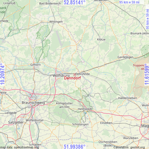
Danndorf GPS coordinates[2]
52° 25' 28.992" North, 10° 54' 46.296" East
| Map corner | latitude | longitude |
|---|---|---|
| Upper-left | 52.85141°, | 10.20974° |
| Center: | 52.42472°, | 10.91286° |
| Lower-right: | 51.99386°, | 11.61599° |
| Map W x H: | 95.4×95.3 km | = 59.3×59.2mi |
| max Lat: | 55.01917° ⇑23.5% North |
| Danndorf: | 52.42472° |
| min Lat: | ⇓76.5% South 47.40724° |
| min Long | Danndorf | max Long |
| 5.92978° | 10.91286° | 14.98853° |
| W 65.7%⇐ | ⇒34.3% E |
Elevation
Elevation of Danndorf is 69 m = 226 ft, and this is 180.1 m = 591 ft below average elevation for this country.
| Max E: |
1256 m = 4121 ft | 73.6% |
| Avg. | 249.1 m = 817 ft | |
| Danndorf | 69 m = 226 ft | |
Min E: |
-5 m = -16 ft | 26.4% |
See also: Germany elevation on elevation.city.
Geographical zone
Danndorf is located in North temperate zone (between Tropic of Cancer and the Arctic Circle). Distance of this North polar circle is 1572.1 km =976.9 mi to North.| Distance of | km | miles | from Danndorf |
|---|---|---|---|
| North Pole | 4178 | 2596.1 | to North |
| Arctic Circle | 1572.1 | 976.9 | to North |
| Tropic Cancer | 3223.2 | 2002.8 | to South |
| Equator | 5829.1 | 3622 | to South |


Nearby cities:
15 places around Danndorf: (largest is in red/bold)
• Bahrdorf
7.3 km =4.5 mi,  126°
126°
• Detmerode
12 km =7.5 mi,  251°
251°
• Grafhorst
3.1 km =1.9 mi,  44°
44°
• Groß Twülpstedt
5.7 km =3.5 mi,  175°
175°
• Jembke
13 km =8.1 mi,  310°
310°
• Oebisfelde
5.2 km =3.2 mi,  78°
78°
• Parsau
12.3 km =7.6 mi,  352°
352°
• Querenhorst
10.8 km =6.7 mi,  160°
160°
• Rothenfelde
8.1 km =5 mi,  271°
271°
• Rühen
7 km =4.3 mi, 345°
• Tappenbeck
12.7 km =7.9 mi,  293°
293°
• Tiddische
12.8 km =8 mi,  323°
323°
• Velpke
2.5 km =1.6 mi,  139°
139°
• Westhagen
12 km =7.5 mi,  259°
259°
• Wolfsburg
8.9 km =5.5 mi, 269°
Sources, notices
• [Note1] Compared only with cities in Germany existing in our database
• [Src1] Map data: © OpenStreetMap contributors (CC-BY-SA)
• [Src2] Other city data from geonames.org with taken over terms of usage.
• [Src3] Geographical zone / Annual Mean Temperature by Robert A. Rohde @ Wikipedia
